1
Trinity Church
The church on the corner of Church Road and Presto Street is now incorporated into Trinity Church and appears to be being used as a Sunday School.
Image: © David Dixon
Taken: 2 May 2010
0.02 miles
2
St Gregory the Great Roman Catholic Church
The first church was founded in 1853 and in 1873 work commenced building the second church, for which the first sod was cut 19 May 1873 and the formal ceremony of dedication took place 11 March 1876. The church closed in 2004, the parish being merged with that of Our Lady of Lourdes, Farnworth.
Image: © David Dixon
Taken: 2 May 2010
0.05 miles
3
Church of St Gregory the Great. Farnworth
The first church was founded in 1853 and in 1873 work commenced building the second church, for which the first sod was cut 19 May 1873 and the formal ceremony of dedication took place 11 March 1876. The church closed in 2004, the parish being merged with that of Our Lady of Lourdes, Farnworth.
Image: © David Dixon
Taken: 2 May 2010
0.05 miles
4
Trinity Church, Market Street, Farnworth
Trinity Church was founded in 1972 on the site of the Farnworth Congregational Church, and completed in 1978. It is a shared church which replaced the Wesleyan Methodist Church on the corner of Church and Presto Streets, the Queen Street Methodist Church, and the Market Street Congregational Church.
Image: © David Dixon
Taken: 2 May 2010
0.05 miles
5
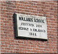
Hollands School: Plaque
The plaque on Hollands School
Image reads:
HOLLANDS SCHOOL
ERECTED, 1810.
REBUILT & ENLARGED
1868.
Image: © Gerald England
Taken: 23 Sep 2022
0.06 miles
6
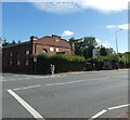
Hollands School
Former school
Image, now a nursing home on Higher Market Street (A6053). The road forms the boundary between Kearsley (on the left) and Farnworth (on the right).
Image: © Gerald England
Taken: 23 Sep 2022
0.06 miles
7
Farnworth, Trinity Church
Methodist church on Market Street. http://www.farnworthandworsley.org.uk/Churches/Trinity
Image: © Mike Faherty
Taken: 18 Oct 2009
0.06 miles
8
Farnworth, Holland's School
On Manchester Road; a plaque states that the building was erected in 1810, and rebuilt in 1868. Now a nursing home.
Image: © Mike Faherty
Taken: 18 Oct 2009
0.06 miles
9
Farnworth Christmas Lights on Market Street
Taken at dusk from outside Trinity Church.
Image: © Bradley Michael
Taken: 17 Dec 2015
0.07 miles
10
Market Street, Farnworth
Image: © Ian S
Taken: 3 Sep 2011
0.07 miles


