IMAGES TAKEN NEAR TO
Brook Street, BOLTON, BL4 7RX
Introduction
This page details the photographs taken nearby to Brook Street, BL4 7RX by members of the Geograph project.
The Geograph project started in 2005 with the aim of publishing, organising and preserving representative images for every square kilometre of Great Britain, Ireland and the Isle of Man.

There are currently over 7.5m images from over14,400 individuals and you can help contribute to the project by visiting https://www.geograph.org.uk
Image Map
Images are licensed for reuse under creativecommons.org/licenses/by-sa/2.0
Notes
- Clicking on the map will re-center to the selected point.
- The higher the marker number, the further away the image location is from the centre of the postcode.
Image Listing (26 Images Found)
Images are licensed for reuse under creativecommons.org/licenses/by-sa/2.0
Image
Details
Distance
1
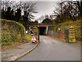
Gate Piers and Darley Park Bridge
The bridge in the background carries the A666 (St Peter's Way).
Image: © David Dixon
Taken: 12 Jan 2015
0.05 miles
2
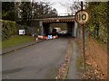
Darley Park Bridge, Farnworth
Bridge carrying St Peter's Way (A666).
Image: © David Dixon
Taken: 12 Jan 2015
0.08 miles
4
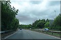
Bridge to Fern Street
The bridge goes over the Bolton-Manchester railway line.
Image: © Bradley Michael
Taken: 25 Oct 2015
0.14 miles
5
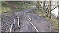
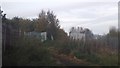
Muddy Track in Moses Gate Country Park
The antecedent weather had been dry. This track is interesting to navigate if you are wanting to avoid muddy shoes!
Image: © Bradley Michael
Taken: 8 Apr 2015
0.15 miles
6
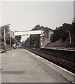
Farnworth Station
Looking in the direction of Bolton.
Image: © Gerald England
Taken: 19 Jul 1986
0.17 miles
7
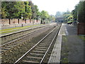
Farnworth railway station, Greater Manchester, 2012
Opened in 1838 as "Tunnel" by the Manchester and Bolton Railway, later part of the Lancashire & Yorkshire Railway, this station closed temporarily in 1841. It reopened in 1845 as "Halshaw Moor" and then went through some variations of "Halshaw Moor & Farnworth" before settling on "Farnworth" in 1974.
View south east towards Kearsley and Manchester a few years before the line was electrified. For an updated view, see Image
Image: © Nigel Thompson
Taken: 13 Oct 2012
0.19 miles
8
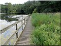
Walkway at Crompton Lodges
In Moses Gate Country Park.
Image: © philandju
Taken: 7 Aug 2014
0.19 miles
9
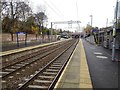
Farnworth railway station, Greater Manchester
Opened in 1838 as "Tunnel" by the Manchester and Bolton Railway, later part of the Lancashire & Yorkshire Railway, this station closed temporarily in 1841. It reopened in 1845 as "Halshaw Moor" and then went through some variations of "Halshaw Moor & Farnworth" before settling on "Farnworth" in 1974.
View south east towards Kearsley and Manchester shortly after the line was electrified.
Image: © Nigel Thompson
Taken: 14 Nov 2018
0.20 miles
10
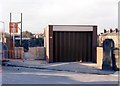
We're closed! Farnworth station building 1989
A minimalist building, designed to be vandal-proof, had been provided at Farnworth in the 1970s, but in 1989 was only open 6am to 2pm for ticket sales.
Image: © Peter Whatley
Taken: 20 Feb 1989
0.22 miles