IMAGES TAKEN NEAR TO
King Street, BOLTON, BL4 7AS
Introduction
This page details the photographs taken nearby to King Street, BL4 7AS by members of the Geograph project.
The Geograph project started in 2005 with the aim of publishing, organising and preserving representative images for every square kilometre of Great Britain, Ireland and the Isle of Man.

There are currently over 7.5m images from over14,400 individuals and you can help contribute to the project by visiting https://www.geograph.org.uk
Image Map
Images are licensed for reuse under creativecommons.org/licenses/by-sa/2.0
Notes
- Clicking on the map will re-center to the selected point.
- The higher the marker number, the further away the image location is from the centre of the postcode.
Image Listing (67 Images Found)
Images are licensed for reuse under creativecommons.org/licenses/by-sa/2.0
Image
Details
Distance
1
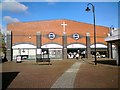
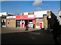
Salvation Army, Farnworth
The citadel at Farnworth includes a coffee shop, community centre and a charity shop.
Image: © Gerald England
Taken: 27 Oct 2017
0.07 miles
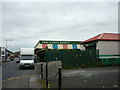
4
Anthony Axford Ltd
Timber merchants and joiners. The site appears to have grown by absorbing neighbouring properties.
Image: © Bill Boaden
Taken: 7 Sep 2015
0.09 miles
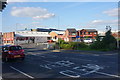
6
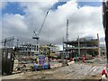
Redevelopment of Farnworth Centre
A mixed development for the centre viewed from King Street
Image: © Kevin Waterhouse
Taken: 26 Feb 2024
0.09 miles
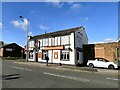
8
Britannia, a free public house
On King Street
Image: © Kevin Waterhouse
Taken: 26 Feb 2024
0.10 miles
9
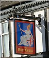
Sign of the Britannia
Sign for the Britannia Image
Image: © Gerald England
Taken: 27 Oct 2017
0.10 miles
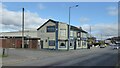
10
The Britannia
King Street, Farnworth.
Image
Image: © Gerald England
Taken: 27 Oct 2017
0.10 miles