IMAGES TAKEN NEAR TO
Buttermere Road, BOLTON, BL4 0PR
Introduction
This page details the photographs taken nearby to Buttermere Road, BL4 0PR by members of the Geograph project.
The Geograph project started in 2005 with the aim of publishing, organising and preserving representative images for every square kilometre of Great Britain, Ireland and the Isle of Man.

There are currently over 7.5m images from over14,400 individuals and you can help contribute to the project by visiting https://www.geograph.org.uk
Image Map (7 Images)


Getting Data...Please wait
Leaflet Map data © OpenStreetMap
Images are licensed for reuse under creativecommons.org/licenses/by-sa/2.0
Notes
- Clicking on the map will re-center to the selected point.
- The higher the marker number, the further away the image location is from the centre of the postcode.
Image Listing (7 Images Found)
Images are licensed for reuse under creativecommons.org/licenses/by-sa/2.0
Image
Details
Distance
1
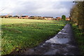
Path to Farnworth
The western edge of Farnworth is visible ahead.
Image: © Bill Boaden
Taken: 3 Dec 2011
0.10 miles
2
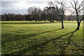
Golf course west of Farnworth
I hadn't worked out whether this was part of the municipal course to the south or the private course to the north. The M61 is through the trees ahead.
Image: © Bill Boaden
Taken: 3 Dec 2011
0.11 miles
3
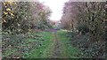
Track near Great Lever & Farnworth Golf Club
Houses in Highfield can be seen faintly in the background. Heading the other way on the track takes you to Moss Hall Farm Cattery.
Image: © Bradley Michael
Taken: 15 Nov 2014
0.14 miles

6
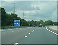
M61 Greenheys
Approaching junction 4 of the M61 at the turn off for Leigh.
Image: © Andy Farrington
Taken: 20 Jun 2011
0.22 miles
7
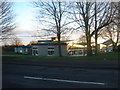
Cherry Tree Primary School, Highfield Road
Image: © Margaret Clough
Taken: 1 Jan 2006
0.23 miles