IMAGES TAKEN NEAR TO
Whins Avenue, BOLTON, BL4 0NP
Introduction
This page details the photographs taken nearby to Whins Avenue, BL4 0NP by members of the Geograph project.
The Geograph project started in 2005 with the aim of publishing, organising and preserving representative images for every square kilometre of Great Britain, Ireland and the Isle of Man.

There are currently over 7.5m images from over14,400 individuals and you can help contribute to the project by visiting https://www.geograph.org.uk
Image Map
Images are licensed for reuse under creativecommons.org/licenses/by-sa/2.0
Notes
- Clicking on the map will re-center to the selected point.
- The higher the marker number, the further away the image location is from the centre of the postcode.
Image Listing (4 Images Found)
Images are licensed for reuse under creativecommons.org/licenses/by-sa/2.0
Image
Details
Distance
1
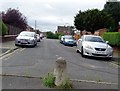
Mount Pleasant Road
The road runs between Plodder Lane and Highfield Road, although there is no longer access from the road onto Plodder lane.
Image: © philandju
Taken: 7 Aug 2020
0.22 miles
2
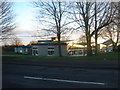
Cherry Tree Primary School, Highfield Road
Image: © Margaret Clough
Taken: 1 Jan 2006
0.24 miles
3
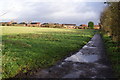
Path to Farnworth
The western edge of Farnworth is visible ahead.
Image: © Bill Boaden
Taken: 3 Dec 2011
0.24 miles
4
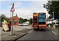
Recycling day on Plodder Lane
Patient drivers are required if travelling up Plodder Lane behind the bin lorry.
Image: © philandju
Taken: 7 Aug 2020
0.24 miles