IMAGES TAKEN NEAR TO
Hopefield Street, BOLTON, BL3 6TW
Introduction
This page details the photographs taken nearby to Hopefield Street, BL3 6TW by members of the Geograph project.
The Geograph project started in 2005 with the aim of publishing, organising and preserving representative images for every square kilometre of Great Britain, Ireland and the Isle of Man.

There are currently over 7.5m images from over14,400 individuals and you can help contribute to the project by visiting https://www.geograph.org.uk
Image Map
Images are licensed for reuse under creativecommons.org/licenses/by-sa/2.0
Notes
- Clicking on the map will re-center to the selected point.
- The higher the marker number, the further away the image location is from the centre of the postcode.
Image Listing (53 Images Found)
Images are licensed for reuse under creativecommons.org/licenses/by-sa/2.0
Image
Details
Distance
1
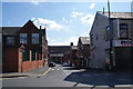
Florence Street, Daubhill
A road off St Helens Road offering a traditional view of Bolton employment.
Image: © Bill Boaden
Taken: 22 Sep 2012
0.06 miles
2
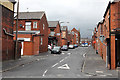
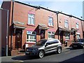
Goldsmith Street
Looking up from Bridgeman Street. A typical area of terraced housing for textile mill workers.
Image: © Alan Murray-Rust
Taken: 21 Aug 2012
0.08 miles
4
Former Co-operative store, Bridgeman Street
The origin is given away by the BCS lettering in terracotta.
Image: © Alan Murray-Rust
Taken: 21 Aug 2012
0.11 miles
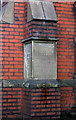
6
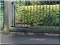
Bench mark, St Philip's Church
This is a pivot mark on the stone coping of the church railings. http://www.geograph.org.uk/photo/3106906
Image: © Alan Murray-Rust
Taken: 21 Aug 2012
0.12 miles
7
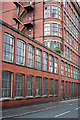
Swan Lane No.3 Mill - 1
The Bridgeman Street facade. One of the pairs of swan sculptures http://www.geograph.org.uk/photo/3106911 can be seen in front of the curved windows.
Image: © Alan Murray-Rust
Taken: 21 Aug 2012
0.12 miles
8
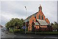
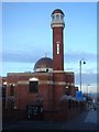
St. Philip's parish church, Bolton-le-Moors
Early 20th century church, started 1909 and consecrated 1911 http://www.geograph.org.uk/photo/3106919 Built in red brick with pale buff terracotta dressings. The church still refers to the full traditional name of the town.
Image: © Alan Murray-Rust
Taken: 21 Aug 2012
0.13 miles
9
Foundation stone, St Philip's Church
The near face commemorates the laying of the stone on August 21st 1909 and the left hand side the consecration on January 25th 1911. http://www.geograph.org.uk/photo/3106906 for a view of the church.
Image: © Alan Murray-Rust
Taken: 21 Aug 2012
0.13 miles
10
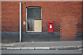
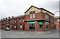
Higher Swan Lane | 500 Bridgeman Street postbox (ref. BL3 230)
GVIR wall boxes are not particularly common. This one is younger than its immediately surrounding buildings, but seems to have been installed to meet the needs of the nearby inter-war infill development of Mancroft Avenue.
Image: © Alan Murray-Rust
Taken: 21 Aug 2012
0.13 miles