IMAGES TAKEN NEAR TO
Crook Street, BOLTON, BL3 6EF
Introduction
This page details the photographs taken nearby to Crook Street, BL3 6EF by members of the Geograph project.
The Geograph project started in 2005 with the aim of publishing, organising and preserving representative images for every square kilometre of Great Britain, Ireland and the Isle of Man.

There are currently over 7.5m images from over14,400 individuals and you can help contribute to the project by visiting https://www.geograph.org.uk
Image Map
Images are licensed for reuse under creativecommons.org/licenses/by-sa/2.0
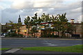
Notes
- Clicking on the map will re-center to the selected point.
- The higher the marker number, the further away the image location is from the centre of the postcode.
Image Listing (221 Images Found)
Images are licensed for reuse under creativecommons.org/licenses/by-sa/2.0
Image
Details
Distance
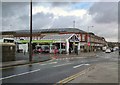
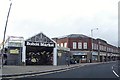
2
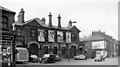
Bolton (Great Moor St.) Station, entrance remains
View SW, to front of station; ex-LNW terminus of lines from Manchester Exchange and from Kenyon Junction. These lines and the station were closed to regular passengers on 28/3/54 but remained for excursion traffic until 1958 and goods until 1960.
Image: © Ben Brooksbank
Taken: 16 Apr 1962
0.06 miles
3
Bolton (Great Moor Street) railway station (site), Greater Manchester
Opened in 1828 as "Bolton" by the Bolton and Leigh Railway, later part of the London & North Western Railway, this station was renamed "Bolton Great Moor Street" in 1849. It closed in 1954 to passengers and completely in 1965, and was subsequently demolished.
View south east at the site of the main entrance building. No trace remains
Image: © Nigel Thompson
Taken: 14 Nov 2018
0.06 miles
4
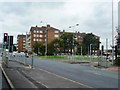
Town centre road junction
Black Horse Street meets Trinity Street in the centre of Bolton.
Image: © philandju
Taken: 4 Jul 2023
0.07 miles
6
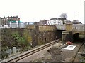
Railway lines out of Bolton
The line to Preston passing under Great Moor Street.
Image: © Gerald England
Taken: 23 Dec 2017
0.09 miles
7
Bolton Skatepark
The skatepark on Dawes Street was designed and built by Freestyle and opened in 2015. https://www.skateparks.co.uk/greater-manchester/bolton-skatepark/
Morrisons supermarket is on the other side of the railway bridge. Pedestrians are advised not to take a short-cut through the skatepark.
Image: © Gerald England
Taken: 23 Dec 2017
0.10 miles
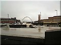
8
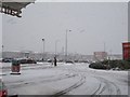
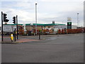
Looking out at the snow
Stopped for fuel and took this photo of the shopping area by Sainsbury's at Bolton.
Image: © Bill Nicholls
Taken: 20 Dec 2009
0.10 miles
9
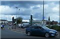
Morrison's in Bolton
Viewed across Trinity Street. The town hall tower is behind.
Image: © Bill Boaden
Taken: 10 Sep 2011
0.10 miles
10
Bolton Market
From Black Horse Street.
Image: © Bradley Michael
Taken: 30 Dec 2015
0.10 miles