IMAGES TAKEN NEAR TO
Thornbank South, BOLTON, BL3 5NZ
Introduction
This page details the photographs taken nearby to Thornbank South, BL3 5NZ by members of the Geograph project.
The Geograph project started in 2005 with the aim of publishing, organising and preserving representative images for every square kilometre of Great Britain, Ireland and the Isle of Man.

There are currently over 7.5m images from over14,400 individuals and you can help contribute to the project by visiting https://www.geograph.org.uk
Image Map
Images are licensed for reuse under creativecommons.org/licenses/by-sa/2.0
Notes
- Clicking on the map will re-center to the selected point.
- The higher the marker number, the further away the image location is from the centre of the postcode.
Image Listing (31 Images Found)
Images are licensed for reuse under creativecommons.org/licenses/by-sa/2.0
Image
Details
Distance
1
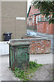
Electricity supply box, Thornbank
This old cast iron supply box has been retained in the redevelopment of the area.
Image: © Alan Murray-Rust
Taken: 25 Jul 2012
0.03 miles
2
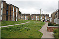
Thornbank, off Wigan Road
Typical 1960s/70s housing development incorporating pedestrian routes and green open space replacing the previously tightly packed Victorian terraced housing.
Image: © Alan Murray-Rust
Taken: 25 Jul 2012
0.03 miles
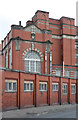
3
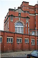
Croal Mill - 2
Offices and gatehouse building. It was a crack in one of the elements of the far entrance in this picture that confirmed that the gray material forming the window surrounds and decorative elements is ceramic and not stone, although it is finished to look like the latter.
Image: © Alan Murray-Rust
Taken: 25 Jul 2012
0.05 miles
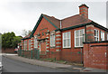
4
Langley Drive
1970s housing development adjacent to Croal Mill. Mainly replacing late 19th century terraces, this particular group are on the site of the former Diamond Brewery of William Tong & Sons http://www.geograph.org.uk/photo/3084116. The tower block is part of the same development.
Image: © Alan Murray-Rust
Taken: 25 Jul 2012
0.05 miles
5
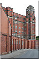
Croal Mill - 1
The fine sweep of the ancillary buildings down Blackshaw Lane with the tower rising behind.
Image: © Alan Murray-Rust
Taken: 25 Jul 2012
0.06 miles
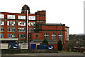
6
Croal Mill - 4
Building detail with engine house. The paler material is ceramic (brick/terracotta) despite giving the appearance of being stone.
Image: © Alan Murray-Rust
Taken: 25 Jul 2012
0.07 miles
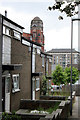
7
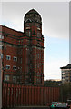
Croal Mill, Bolton
A Grade II Listed Edwardian spinning mill built in 1907. Designed by Bradshaw, Gass & Hope. The engine house with three tall round-headed windows housed a 1300 horsepower inverted vertical triple expansion engine by Yates and Thom of Blackburn in 1908. The engine was named Shelagh and had Corliss valve cylinders 21.5, 34 & 55" bores by 4' stroke. It ran at 82 rpm on steam at 160 psi and drove by 36 cotton ropes from the 22' 6" flywheel.
The Lumb governor from this engine is in the Birmingham Museums Store and the Shelagh nameplate is at the Bolton Steam Museum.
Image: © Chris Allen
Taken: 30 Mar 2008
0.07 miles
8
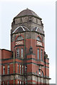
Croal Mill - 3
Detail of the tower. The close detail shows that the grey areas are brickwork rather than stone; the decorative elements are also ceramic (terracotta).
Image: © Alan Murray-Rust
Taken: 25 Jul 2012
0.07 miles
10
Croal Mill stair tower
This shows fine detailing on the stair tower. There is a square section column of lavatories in the angle between tower and mill (given away by the external plumbing). The weather chose this moment to turn nasty and bring activities to a close for the day.
Image: © Chris Allen
Taken: 30 Mar 2008
0.08 miles