IMAGES TAKEN NEAR TO
Deane Road, BOLTON, BL3 5HH
Introduction
This page details the photographs taken nearby to Deane Road, BL3 5HH by members of the Geograph project.
The Geograph project started in 2005 with the aim of publishing, organising and preserving representative images for every square kilometre of Great Britain, Ireland and the Isle of Man.

There are currently over 7.5m images from over14,400 individuals and you can help contribute to the project by visiting https://www.geograph.org.uk
Image Map
Images are licensed for reuse under creativecommons.org/licenses/by-sa/2.0
Notes
- Clicking on the map will re-center to the selected point.
- The higher the marker number, the further away the image location is from the centre of the postcode.
Image Listing (38 Images Found)
Images are licensed for reuse under creativecommons.org/licenses/by-sa/2.0
Image
Details
Distance
3
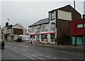
Bolton, Lincoln Mill
In Washington Street, formerly manufacturing quilts; now the seat of Bolton Enterprise Centre. http://www.bbvonline.net/boltonenterprisecentre.asp
Image: © Mike Faherty
Taken: 13 Jan 2011
0.06 miles
6
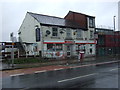
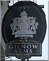
Spar Shop on Deane Road, Gilnow
Formerly the Gibraltar Rock Hotel.
Image: © JThomas
Taken: 28 Mar 2015
0.10 miles
7
Bolton, Gibraltar Rock Hotel
Converted pub on Deane Road, still surprisingly bearing its pub signage; now a convenience store.
Image: © Mike Faherty
Taken: 13 Jan 2011
0.10 miles
8
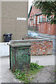
Electricity supply box, Thornbank
This old cast iron supply box has been retained in the redevelopment of the area.
Image: © Alan Murray-Rust
Taken: 25 Jul 2012
0.13 miles
9
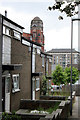
Langley Drive
1970s housing development adjacent to Croal Mill. Mainly replacing late 19th century terraces, this particular group are on the site of the former Diamond Brewery of William Tong & Sons http://www.geograph.org.uk/photo/3084116. The tower block is part of the same development.
Image: © Alan Murray-Rust
Taken: 25 Jul 2012
0.13 miles
10
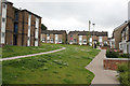
Thornbank, off Wigan Road
Typical 1960s/70s housing development incorporating pedestrian routes and green open space replacing the previously tightly packed Victorian terraced housing.
Image: © Alan Murray-Rust
Taken: 25 Jul 2012
0.13 miles