IMAGES TAKEN NEAR TO
Chesterton Drive, BOLTON, BL3 4RT
Introduction
This page details the photographs taken nearby to Chesterton Drive, BL3 4RT by members of the Geograph project.
The Geograph project started in 2005 with the aim of publishing, organising and preserving representative images for every square kilometre of Great Britain, Ireland and the Isle of Man.

There are currently over 7.5m images from over14,400 individuals and you can help contribute to the project by visiting https://www.geograph.org.uk
Image Map
Images are licensed for reuse under creativecommons.org/licenses/by-sa/2.0
Notes
- Clicking on the map will re-center to the selected point.
- The higher the marker number, the further away the image location is from the centre of the postcode.
Image Listing (5 Images Found)
Images are licensed for reuse under creativecommons.org/licenses/by-sa/2.0
Image
Details
Distance
1
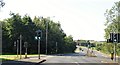
The turning onto Armadale Road
From Beaumont Road.
Image: © philandju
Taken: 31 Jul 2020
0.09 miles
2
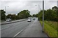
The A58 Beaumont Road
I can remember when this was cobbled. They were very late putting a modern surface on what was possibly one of the earliest bypasses or ring roads in the country.
Image: © Ian Greig
Taken: 8 Jun 2012
0.09 miles
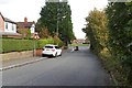
5
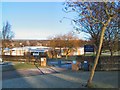
Ladybridge Primary School
School's out for the Xmas holidays, and the gates are locked.
Image: © Roger May
Taken: 28 Dec 2005
0.14 miles