IMAGES TAKEN NEAR TO
Hawkshead Drive, BOLTON, BL3 4QY
Introduction
This page details the photographs taken nearby to Hawkshead Drive, BL3 4QY by members of the Geograph project.
The Geograph project started in 2005 with the aim of publishing, organising and preserving representative images for every square kilometre of Great Britain, Ireland and the Isle of Man.

There are currently over 7.5m images from over14,400 individuals and you can help contribute to the project by visiting https://www.geograph.org.uk
Image Map
Images are licensed for reuse under creativecommons.org/licenses/by-sa/2.0
Notes
- Clicking on the map will re-center to the selected point.
- The higher the marker number, the further away the image location is from the centre of the postcode.
Image Listing (5 Images Found)
Images are licensed for reuse under creativecommons.org/licenses/by-sa/2.0
Image
Details
Distance
3
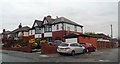
Fernhill Convenience Store
A corner shop on the corner of Greenhill Lane and Wigan Road. The flats on the left are quite new. Through the gap can be seen Ladybridge High school.
Image: © Bill Boaden
Taken: 8 Sep 2015
0.22 miles
4
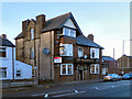
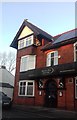
The Rumwoth
The Rumworth public house on Wigan Road (A676).
Image: © David Dixon
Taken: 8 Jan 2011
0.24 miles