IMAGES TAKEN NEAR TO
Fernhill Avenue, BOLTON, BL3 4JS
Introduction
This page details the photographs taken nearby to Fernhill Avenue, BL3 4JS by members of the Geograph project.
The Geograph project started in 2005 with the aim of publishing, organising and preserving representative images for every square kilometre of Great Britain, Ireland and the Isle of Man.

There are currently over 7.5m images from over14,400 individuals and you can help contribute to the project by visiting https://www.geograph.org.uk
Image Map
Images are licensed for reuse under creativecommons.org/licenses/by-sa/2.0
Notes
- Clicking on the map will re-center to the selected point.
- The higher the marker number, the further away the image location is from the centre of the postcode.
Image Listing (24 Images Found)
Images are licensed for reuse under creativecommons.org/licenses/by-sa/2.0
Image
Details
Distance
1
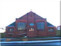
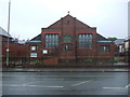
Deane United Reformed Church
Church on the A676 at Deane.
Image: © Roger May
Taken: 28 Dec 2005
0.07 miles

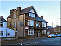
4
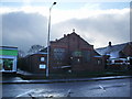
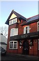
Dental surgery on Wigan Road
The building was previously a pub - the Rumworth Arms.
Image: © philandju
Taken: 3 Jul 2017
0.11 miles
5
Deane United Reformed Church, Bolton
Image: © Alexander P Kapp
Taken: 31 Jan 2008
0.11 miles
6
Deane United Reformed Church
On Wigan Road (A676).
Image: © JThomas
Taken: 28 Mar 2015
0.13 miles
8
Deane United Reformed Church
The hall on the right is used for community activities but the Seddon banner on it is ominous. Is it going to be redeveloped?
Image: © Bill Boaden
Taken: 8 Sep 2015
0.13 miles
9
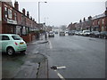
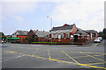
Co-operative food store, Deane
On Wigan Road (A676).
Image: © JThomas
Taken: 28 Mar 2015
0.13 miles
10
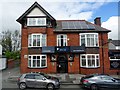
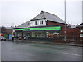
The Rumwoth
The Rumworth public house on Wigan Road (A676).
Image: © David Dixon
Taken: 8 Jan 2011
0.14 miles