IMAGES TAKEN NEAR TO
Park View Road, BOLTON, BL3 4BE
Introduction
This page details the photographs taken nearby to Park View Road, BL3 4BE by members of the Geograph project.
The Geograph project started in 2005 with the aim of publishing, organising and preserving representative images for every square kilometre of Great Britain, Ireland and the Isle of Man.

There are currently over 7.5m images from over14,400 individuals and you can help contribute to the project by visiting https://www.geograph.org.uk
Image Map
Images are licensed for reuse under creativecommons.org/licenses/by-sa/2.0
Notes
- Clicking on the map will re-center to the selected point.
- The higher the marker number, the further away the image location is from the centre of the postcode.
Image Listing (7 Images Found)
Images are licensed for reuse under creativecommons.org/licenses/by-sa/2.0
Image
Details
Distance
1
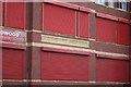
Brandwood Community Primary School
One has to wonder how much of a community spirit this extent of protection actually fosters, but one has to assume that the school has been the target of vandalism in the past.
Image: © Alan Murray-Rust
Taken: 21 Aug 2012
0.03 miles
2
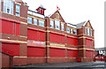
Brandwood Street County School
The original name of the school in yellow-buff terracotta. It dates from around 1900.
Image: © Alan Murray-Rust
Taken: 21 Aug 2012
0.04 miles
3
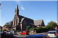
St George the Martyr, Daubhill
A very well tended church but there is nothing outside to say what it is.
Image: © Bill Boaden
Taken: 22 Sep 2012
0.19 miles
4
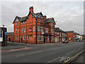
Rumworth Hall, Daubhill
Rumworth Hall, at the corner of Prescott Street and St Helens Road.
Image: © David Dixon
Taken: 3 Jan 2011
0.20 miles
5
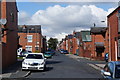
Croston Street, Daubhill
A view of traditional terraced housing.
Image: © Bill Boaden
Taken: 22 Sep 2012
0.21 miles
6
The Oddfellows
The Oddfellows Arms, St Helens Road, Daubhill, Bolton
Image: © David Dixon
Taken: 3 Jan 2011
0.21 miles
7
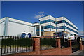
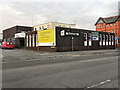
Park Cakes, Daubhill
The headquarters are in Oldham, but this is the other main site.
Image: © Bill Boaden
Taken: 22 Sep 2012
0.23 miles