IMAGES TAKEN NEAR TO
Eastmoor Grove, BOLTON, BL3 3RY
Introduction
This page details the photographs taken nearby to Eastmoor Grove, BL3 3RY by members of the Geograph project.
The Geograph project started in 2005 with the aim of publishing, organising and preserving representative images for every square kilometre of Great Britain, Ireland and the Isle of Man.

There are currently over 7.5m images from over14,400 individuals and you can help contribute to the project by visiting https://www.geograph.org.uk
Image Map
Images are licensed for reuse under creativecommons.org/licenses/by-sa/2.0
Notes
- Clicking on the map will re-center to the selected point.
- The higher the marker number, the further away the image location is from the centre of the postcode.
Image Listing (13 Images Found)
Images are licensed for reuse under creativecommons.org/licenses/by-sa/2.0
Image
Details
Distance
1
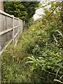
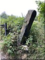
Restricted byway
Off Smethurst Lane. Just a short distance down the byway are the remains of a stile and at the Slack Fold entrance to the byway there is no proper access other than by foot.
Image: © Kevin Waterhouse
Taken: 8 Apr 2024
0.08 miles
2
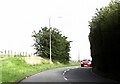
Smethurst Lane in Bolton
Smethurst Lane came at the last half mile on the old route of the Bolton Marathon back in the 1980s. After toiling up the 2 mile long incline of Plodder Lane, runners were faced with the exhausting, daunting, and much steeper (if shorter) incline on Smethurst Lane. The relief on reaching the crest of the hill, with the finish line in sight below, was massive.
Image: © philandju
Taken: 7 Aug 2020
0.17 miles
3
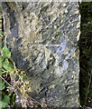
OS Cut Mark - Bolton, Cow Lane
https://www.bench-marks.org.uk/bm97186
Image: © thejackrustles
Taken: 21 Jul 2022
0.17 miles
4
OS Cut Mark - Bolton, Cow Lane
https://www.bench-marks.org.uk/bm97186
Image: © thejackrustles
Taken: 21 Jul 2022
0.17 miles
5
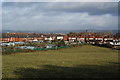
Horse grazing and Sapling Road Allotments
There are no horses currently in the field. This is the view from Lever Edge looking across Bolton.
Image: © Bill Boaden
Taken: 3 Dec 2011
0.19 miles
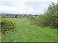
6
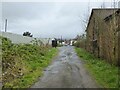
Cow Lane
An old route heading towards St Helens Road
Image: © Kevin Waterhouse
Taken: 8 Apr 2024
0.19 miles
7
Path crossing on Lever Edge
Two paths cross here in a horse-assisted mud bath. Lever Edge Academy is at the foot of the hill.
Image: © Bill Boaden
Taken: 3 Dec 2011
0.19 miles
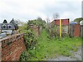
8
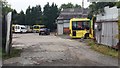
Cumfybus Depot, Cow Lane
The buses have a bumpy ride on Cow Lane before joining St Helens Road - which appropriately has bus lanes.
Image: © Bradley Michael
Taken: 14 Sep 2015
0.19 miles
9
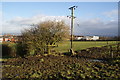
Path to Daubhill
The path joins restricted byways at the camera position
Image: © Kevin Waterhouse
Taken: 8 Apr 2024
0.20 miles