IMAGES TAKEN NEAR TO
St. Dominics Mews, BOLTON, BL3 3NX
Introduction
This page details the photographs taken nearby to St. Dominics Mews, BL3 3NX by members of the Geograph project.
The Geograph project started in 2005 with the aim of publishing, organising and preserving representative images for every square kilometre of Great Britain, Ireland and the Isle of Man.

There are currently over 7.5m images from over14,400 individuals and you can help contribute to the project by visiting https://www.geograph.org.uk
Image Map
Images are licensed for reuse under creativecommons.org/licenses/by-sa/2.0
Notes
- Clicking on the map will re-center to the selected point.
- The higher the marker number, the further away the image location is from the centre of the postcode.
Image Listing (16 Images Found)
Images are licensed for reuse under creativecommons.org/licenses/by-sa/2.0
Image
Details
Distance
1
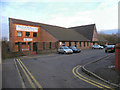
Church of the Nazarene
Church of the Nazarene, a Wesleyan-Evangelical church on Southend Street, at Daubhill.
http://church-of-the-nazarene-bolton.webeden.co.uk/ church website
Image: © David Dixon
Taken: 3 Jan 2011
0.15 miles
2
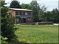
Deane & Derby Cricket Club - Pavilion
Deane and Derby CC's three teams play their cricket in the Manchester & District Cricket Association.
Image: © BatAndBall
Taken: 30 May 2012
0.15 miles
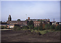
3
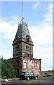
Sunnyside Mills tower
Only a small part of the once extensive Sunnyside Mills remains. They belonged to the famous firm of Tootal Broadhurst Lee and Co who were well known for men's ties and woven scarves. The 1872 date probably refers to the building date of this part of the mill.
Image: © Alan Murray-Rust
Taken: 21 Aug 2012
0.16 miles
4
Sunnyside Mills, Adelaide street, Daubhill
I posted this earlier as Bury and then decided to reject it because I wasn't sure. Thanks to Robert Wade and Rossendale Online, I have relocated it to Bolton.
The tower with flag pole is Sunnyside Mills, home to Tootal, Broadhurst and Lee. This site has largely been redeveloped and the tower has gone.
Photographer location is uncertain.
Image: © Chris Allen
Taken: 15 Oct 1994
0.16 miles
5
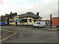
The Morris Dancers
Public House at the corner of Sapling Road and Morris Green Lane.
Image: © David Dixon
Taken: 3 Jan 2011
0.16 miles
6
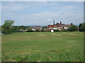
Deane & Derby Cricket Club
Deane and Derby Cricket Club's Sunnyside Park pitch.
Image: © BatAndBall
Taken: 30 May 2012
0.17 miles
7
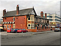
The Manor House
The Manor House (formerly the Stags Head public house), 200 St Helens Road, Daubhill, Bolton.
Image: © David Dixon
Taken: 3 Jan 2011
0.19 miles
9
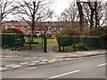
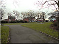
Morris Green Park
The entrance to Morris Green Park, at the corner of Morris Green and Morris Green Lane.
Image: © David Dixon
Taken: 3 Jan 2011
0.19 miles
10
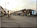
St Helens Road
The traffic lights at the junction of St Helens Road (A579) with Deane Church Lane and Morris Green Lane.
Image: © David Dixon
Taken: 3 Jan 2011
0.20 miles