IMAGES TAKEN NEAR TO
Milford Road, BOLTON, BL3 3DH
Introduction
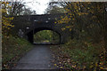
This page details the photographs taken nearby to Milford Road, BL3 3DH by members of the Geograph project.
The Geograph project started in 2005 with the aim of publishing, organising and preserving representative images for every square kilometre of Great Britain, Ireland and the Isle of Man.

There are currently over 7.5m images from over14,400 individuals and you can help contribute to the project by visiting https://www.geograph.org.uk
Image Map
Images are licensed for reuse under creativecommons.org/licenses/by-sa/2.0
Notes
- Clicking on the map will re-center to the selected point.
- The higher the marker number, the further away the image location is from the centre of the postcode.
Image Listing (23 Images Found)
Images are licensed for reuse under creativecommons.org/licenses/by-sa/2.0
Image
Details
Distance
1
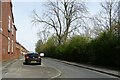
Pennington Road
The wooded area on the right was the site of a now demolished railway which connected Bolton Great Moor Street station with Plodder Lane station. The line was closed in the mid 1960s.
Image: © philandju
Taken: 17 Apr 2022
0.08 miles
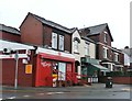
2
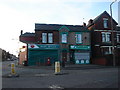
Post Office, Lever Edge
At junction of Green Lane, Lever Edge Lane and Rishton Lane.
Image: © Margaret Clough
Taken: 21 Jan 2006
0.09 miles
3
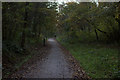
Route 55 south of Settle St.
This is the old railway line that once ran between Bolton Great Moor St station and Manchester Exchange. Closed to passengers in 1954.
Image: © Robert Eva
Taken: 17 Nov 2017
0.10 miles
4
Rupert Street
The street is so named because, on 28th May 1644 during the English civil war, Royalist forces commanded by Prince Rupert marched on parliamentarian Bolton from their camp around this area. The resulting bloody battle allegedly saw some 1600 Bolton residents killed and the naming of the conflict as the Bolton Massacre.
Image: © philandju
Taken: 17 Apr 2022
0.10 miles
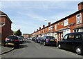
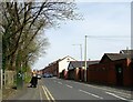
7
Houses on Rishton Lane
Close to its junction with Green Lane, in Great Lever, a suburb of Bolton.
Image: © philandju
Taken: 30 Jul 2020
0.14 miles
9
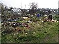
Unworked Allotment
The plot in the foreground has only recently been let and awaits a tidy up.
Image: © Phil Platt
Taken: 24 Mar 2011
0.15 miles
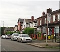
10
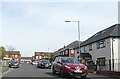
Anfield Road, Lever Edge
A number of streets in the area are named after districts of Liverpool.
Image: © philandju
Taken: 17 Apr 2022
0.16 miles