IMAGES TAKEN NEAR TO
Manchester Road, BOLTON, BL3 2NE
Introduction
This page details the photographs taken nearby to Manchester Road, BL3 2NE by members of the Geograph project.
The Geograph project started in 2005 with the aim of publishing, organising and preserving representative images for every square kilometre of Great Britain, Ireland and the Isle of Man.

There are currently over 7.5m images from over14,400 individuals and you can help contribute to the project by visiting https://www.geograph.org.uk
Image Map
Images are licensed for reuse under creativecommons.org/licenses/by-sa/2.0
Notes
- Clicking on the map will re-center to the selected point.
- The higher the marker number, the further away the image location is from the centre of the postcode.
Image Listing (18 Images Found)
Images are licensed for reuse under creativecommons.org/licenses/by-sa/2.0
Image
Details
Distance
2
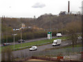
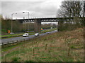
St Peter's Way (A666)
Looking across St Peter's Way from the old Burnden railway embankment.
Image: © David Dixon
Taken: 2 Apr 2012
0.06 miles
3
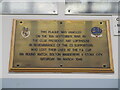
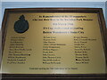
Original Burnden Park Disaster Plaque
First unveiled at Bolton Wanderers FC's former home ground which stood on this site. Bolton left Burnden Park after 102 years in 1997 and the ground was eventually demolished 2 years later. The Asda store on the site opened in 2005 with the plaque placed above the cash tills. Another plaque with the names of those who never made it home was unveiled on the 70th anniversary by the store exit Image
Image: © El Loco
Taken: 5 Dec 2021
0.06 miles
4
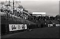
The Railway End terrace at Burnden Park
Burnden Park is the former home of Bolton Wanderers. On 9 March 1946, the Railway End was the scene of the Burnden Park disaster, which at the time was the worst tragedy in British football history. 33 Bolton Wanderers fans were crushed to death, and another 400 injured, in an FA Cup quarter-final second leg tie between Bolton and Stoke City.
Image: © Steve Daniels
Taken: 27 Dec 1983
0.06 miles
5
Burnden Park Disaster Memorial Plaque
Found in the exit area of the ASDA store built on the site of Bolton Wanderers former ground. (The original memorial plaque unveiled by Nat Lofthouse which doesn't include the names of those who never went home is inside the store itself above the tills.)
Image: © El Loco
Taken: 29 May 2021
0.06 miles
6
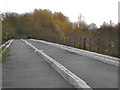
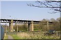
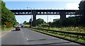
The Burnden Viaduct
Looking along the deck of the, now disused, Burnden Railway Viaduct (Image]). The viaduct, a Grade II listed structure (http://www.britishlistedbuildings.co.uk/en-489719-burden-viaduct-bolton British Listed Buildings), was originally opened in 1848 for the Liverpool and Bury (later the Lancashire and Yorkshire) Railway. The line was closed to passenger traffic in 1951 and then closed completely in 1970.
Image: © David Dixon
Taken: 2 Apr 2012
0.07 miles
7
Burnden Viaduct, Bolton
Former railway viaduct now a walkway/cycleway.
Image: © Colin Park
Taken: 18 Oct 2018
0.07 miles
8
Burnden Viaduct
This viaduct was originally opened in 1848 for the Liverpool and Bury (later the Lancashire and Yorkshire) Railway. The line was closed to passenger traffic in 1951 and then closed completely in 1970. The embankment to the right of the viaduct (as we look in this picture) formed one end of Bolton Wanderers' Burnden Park Football Stadium. All other traces of the railway embankment have gone; presumably the only thing saving the viaduct from demolition is its Grade II listed status (http://www.britishlistedbuildings.co.uk/en-489719-burden-viaduct-bolton British Listed Buildings).
When built, the viaduct crossed the River Croal and the Manchester, Bolton and Bury Canal. The latter has long since been filled in and now the busy A666 (St Peter's Way) passes under this end of the viaduct.
Image: © David Dixon
Taken: 2 Apr 2012
0.07 miles
10
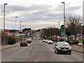
Manchester Road, Burnden
The A666, Manchester Road, passing through Burnden
Image: © David Dixon
Taken: 14 Feb 2010
0.12 miles