IMAGES TAKEN NEAR TO
Lynwood Avenue, BOLTON, BL3 2LS
Introduction
This page details the photographs taken nearby to Lynwood Avenue, BL3 2LS by members of the Geograph project.
The Geograph project started in 2005 with the aim of publishing, organising and preserving representative images for every square kilometre of Great Britain, Ireland and the Isle of Man.

There are currently over 7.5m images from over14,400 individuals and you can help contribute to the project by visiting https://www.geograph.org.uk
Image Map
Images are licensed for reuse under creativecommons.org/licenses/by-sa/2.0
Notes
- Clicking on the map will re-center to the selected point.
- The higher the marker number, the further away the image location is from the centre of the postcode.
Image Listing (22 Images Found)
Images are licensed for reuse under creativecommons.org/licenses/by-sa/2.0
Image
Details
Distance
1
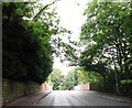
Railway bridge
The bridge carries Green Lane over the Bolton to Manchester line.
Image: © philandju
Taken: 30 Jul 2020
0.15 miles
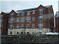
2
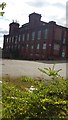
Horrockses Mill
Viewed from Brentwood Drive. My name inspired my visit to the mill!
Image: © Bradley Michael
Taken: 4 Sep 2015
0.16 miles
3
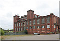
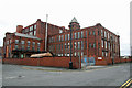
Horrockses Mill - 3
View from the north west showing the substantial corner towers of the main spinning mill flanking a panel with the firm's name and the building date prominently displayed. The lower building in the foreground would have provided for ancillary processes, possibly carding and warehousing.
Image: © Alan Murray-Rust
Taken: 21 Aug 2012
0.17 miles
4
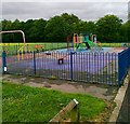
Play area off Cawdor Avenue, Harper Green
Image: © Alex McGregor
Taken: 13 Jun 2011
0.17 miles
5
Horrocks's Mill. Moses Gate, Bolton
This was a large integrated cotton mill with both a multi-storey spinning mill and a large weaving shed. The latter had its own large steam engine but the shed has now been demolished leaving this block of 1915. The deceptively small engine house was home to a 2,400 horsepower Yates & Thom horizontal cross compound with Corliss valve cylinders 33" & 66" x 4'6". This was scrapped in the 1960s.
Image: © Chris Allen
Taken: 6 Apr 2014
0.18 miles
6
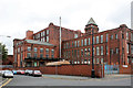
Horrockses Mill - 2
View from the south west at Stockton Street. The main 5-storey spinning mill is at the back with processing/preparation to the right foreground and the engine house projecting to the left.
Image: © Alan Murray-Rust
Taken: 21 Aug 2012
0.18 miles
7
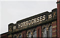
Horrockses Mill - 4
Close up view of the name and date on the spinning mill.
Image: © Alan Murray-Rust
Taken: 21 Aug 2012
0.19 miles
9
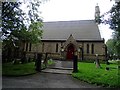
St. Michael's Church
A Church of England church off Green Lane in Bolton.
Image: © philandju
Taken: 18 Aug 2019
0.19 miles
10
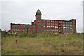
Horrockses Mill - 1
View from the south east across the area once occupied by the weaving mill.
Image: © Alan Murray-Rust
Taken: 21 Aug 2012
0.20 miles