IMAGES TAKEN NEAR TO
Carter Street, BOLTON, BL3 2HQ
Introduction
This page details the photographs taken nearby to Carter Street, BL3 2HQ by members of the Geograph project.
The Geograph project started in 2005 with the aim of publishing, organising and preserving representative images for every square kilometre of Great Britain, Ireland and the Isle of Man.

There are currently over 7.5m images from over14,400 individuals and you can help contribute to the project by visiting https://www.geograph.org.uk
Image Map
Images are licensed for reuse under creativecommons.org/licenses/by-sa/2.0
Notes
- Clicking on the map will re-center to the selected point.
- The higher the marker number, the further away the image location is from the centre of the postcode.
Image Listing (30 Images Found)
Images are licensed for reuse under creativecommons.org/licenses/by-sa/2.0
Image
Details
Distance
1
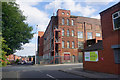
Asia Mill
There is still business activity going on inside.
Image: © Bill Boaden
Taken: 7 Sep 2015
0.01 miles
2
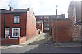
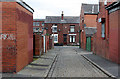
Back Crescent Road, Bolton
An back street in stereotypical former industrial surroundings.
Image: © Bill Boaden
Taken: 7 Sep 2015
0.02 miles
3
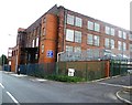
Mill - The Natural Duvet & Pillow Company
Image: © Anthony Parkes
Taken: 19 Sep 2011
0.05 miles
4
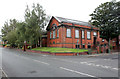
Former Great Lever Branch Library
This carries the date 1909, now rather concealed by the birch trees flanking the main entrance. This end of the building included a children's library with a separate entrance to the right. The building is now a community centre. It was designed by the prominent local architectural firm Bradshaw Hope & Gass http://www.geograph.org.uk/photo/3081382
Image: © Alan Murray-Rust
Taken: 21 Aug 2012
0.06 miles
5
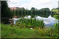
Bradford Reservoir, Great Lever
Originally to benefit the local mills, its only use now is for fishing.
Image: © Bill Boaden
Taken: 7 Sep 2015
0.07 miles
6
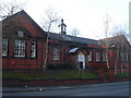
Great Lever Community Centre
This building was once Great Lever Branch Library.
Image: © Margaret Clough
Taken: 21 Jan 2006
0.09 miles
7
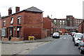
Back Bradford Street
Late Victorian terraced housing development, with adjacent cotton mill just visible through a gap.
Image: © Alan Murray-Rust
Taken: 21 Aug 2012
0.10 miles
8

Junction of Crescent Road and Bradford Road
Image: © philandju
Taken: 7 Aug 2020
0.13 miles
9
Eustace Street
Looking down to Bee Hive Mills, where most of the residents would probably have lived. Note the remains of painted adverts on both the nearer and bottom gable walls.
Image: © Alan Murray-Rust
Taken: 21 Aug 2012
0.14 miles
10
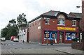
Branch No.45
The number is an immediate indication that this was formerly a Co-operative store. The building beyond http://www.geograph.org.uk/photo/3105650 also displays similar origins.
Image: © Alan Murray-Rust
Taken: 21 Aug 2012
0.15 miles