IMAGES TAKEN NEAR TO
Rutland Close, BOLTON, BL3 1XD
Introduction
This page details the photographs taken nearby to Rutland Close, BL3 1XD by members of the Geograph project.
The Geograph project started in 2005 with the aim of publishing, organising and preserving representative images for every square kilometre of Great Britain, Ireland and the Isle of Man.

There are currently over 7.5m images from over14,400 individuals and you can help contribute to the project by visiting https://www.geograph.org.uk
Image Map
Images are licensed for reuse under creativecommons.org/licenses/by-sa/2.0
Notes
- Clicking on the map will re-center to the selected point.
- The higher the marker number, the further away the image location is from the centre of the postcode.
Image Listing (9 Images Found)
Images are licensed for reuse under creativecommons.org/licenses/by-sa/2.0
Image
Details
Distance
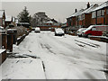
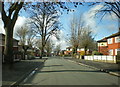
1
Lancaster Drive on a wet day
A residential road with no notable distinguishing features.
Image: © Bill Boaden
Taken: 4 Apr 2022
0.04 miles
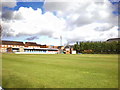
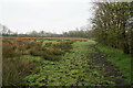
2
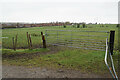
Farmland by Grundy Fold Farm
An enclave of surviving farmland between Little Lever and Radcliffe.
Image: © Bill Boaden
Taken: 4 Apr 2022
0.16 miles
3
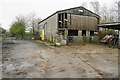
Footpath through Grundy Fold Farm
The path runs to the left of the barn and through the gate.
Image: © Bill Boaden
Taken: 4 Apr 2022
0.16 miles
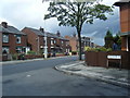
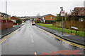
7
Road junction in Little Lever on a wet day
Five roads meet at this point.
Image: © Bill Boaden
Taken: 4 Apr 2022
0.21 miles
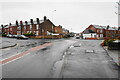
8
Footpath near Grundy Fold Farm
The path is on remaining farmland on the edge of Little Lever. It is part of the Rotary Way which circles round Bolton.
Image: © Bill Boaden
Taken: 4 Apr 2022
0.23 miles