IMAGES TAKEN NEAR TO
Aintree Road, BOLTON, BL3 1ER
Introduction
This page details the photographs taken nearby to Aintree Road, BL3 1ER by members of the Geograph project.
The Geograph project started in 2005 with the aim of publishing, organising and preserving representative images for every square kilometre of Great Britain, Ireland and the Isle of Man.

There are currently over 7.5m images from over14,400 individuals and you can help contribute to the project by visiting https://www.geograph.org.uk
Image Map
Images are licensed for reuse under creativecommons.org/licenses/by-sa/2.0
Notes
- Clicking on the map will re-center to the selected point.
- The higher the marker number, the further away the image location is from the centre of the postcode.
Image Listing (35 Images Found)
Images are licensed for reuse under creativecommons.org/licenses/by-sa/2.0
Image
Details
Distance
1
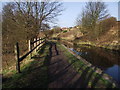
Canal and Towpath
The Bolton spur of the disused Manchester, Bolton, Bury Canal. According to an old mile marker stone beside the towpath, a barge travelling to Manchester from here had eight and a quarter miles to go.
Image: © philandju
Taken: 13 Mar 2012
0.11 miles
2
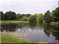
Family of swans on the Manchester,Bolton and Bury Canal
The scene near Little Lever where there is a canal basin
Image: © Raymond Knapman
Taken: 26 Jul 2012
0.11 miles
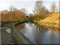
3
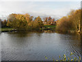
Manchester, Bolton & Bury Canal; Top o? th? Lodge
The canal widens at “Top o’ th’ Lodge” where there used to be a boatyard.
Image: © David Dixon
Taken: 14 Nov 2010
0.11 miles
4
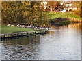
Manchester, Bolton & Bury Canal; Top o? th? Lodge
Image: © David Dixon
Taken: 14 Nov 2010
0.12 miles
6
Manchester, Bolton & Bury Canal, Nob End
Looking north on the Bolton arm of the canal, behind Carlisle Close.
Image: © David Dixon
Taken: 14 Nov 2010
0.17 miles
7
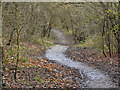
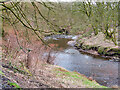
Moses Gate Country Park
Wooded pathway above the east bank of the River Croal.
Image: © David Dixon
Taken: 14 Nov 2010
0.17 miles
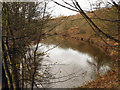
10
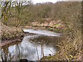
Moses Gate Country Park, River Croal
Looking upstream near the weir that served The Prestolee Chemical works which made chemicals for bleaching and printing (and later washing soda) between 1805 and 1875.
Image: © David Dixon
Taken: 5 Mar 2021
0.18 miles