IMAGES TAKEN NEAR TO
Fearney Side, BOLTON, BL3 1BU
Introduction
This page details the photographs taken nearby to Fearney Side, BL3 1BU by members of the Geograph project.
The Geograph project started in 2005 with the aim of publishing, organising and preserving representative images for every square kilometre of Great Britain, Ireland and the Isle of Man.

There are currently over 7.5m images from over14,400 individuals and you can help contribute to the project by visiting https://www.geograph.org.uk
Image Map
Images are licensed for reuse under creativecommons.org/licenses/by-sa/2.0
Notes
- Clicking on the map will re-center to the selected point.
- The higher the marker number, the further away the image location is from the centre of the postcode.
Image Listing (13 Images Found)
Images are licensed for reuse under creativecommons.org/licenses/by-sa/2.0
Image
Details
Distance
1
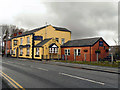
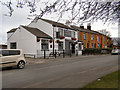
Jolly Carter
The Jolly Carter public house and restaurant on Church Street, Little Lever
Image: © David Dixon
Taken: 14 Nov 2010
0.09 miles
5
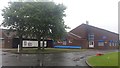
Bowness Primary School
Currently closed for the summer holidays. Little Lever School is out of shot, to the left of the primary school from this view.
Image: © Bradley Michael
Taken: 19 Aug 2015
0.18 miles
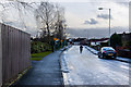
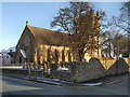
7
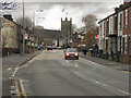
Church Street, Little Lever
Looking along Church Street towards The Parish Church of St Matthew.
Image: © David Dixon
Taken: 14 Nov 2010
0.21 miles
8
Graveyard, St Matthew's Church
Looking over the graveyard at the front of St Matthew's Church, towards Church Road.
Image: © David Dixon
Taken: 21 Jan 2013
0.23 miles
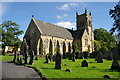
10
The Parish Church of Saint Matthew, Little Lever
St Matthew's was built in 1865 to replace an earlier church built in 1791 on the other side of the street. The tower was increased in height in 1924 as a memorial to parishioners killed during the First World War (Image]).
Image: © David Dixon
Taken: 22 Jan 2013
0.24 miles