IMAGES TAKEN NEAR TO
Harpford Drive, BOLTON, BL2 6TW
Introduction
This page details the photographs taken nearby to Harpford Drive, BL2 6TW by members of the Geograph project.
The Geograph project started in 2005 with the aim of publishing, organising and preserving representative images for every square kilometre of Great Britain, Ireland and the Isle of Man.

There are currently over 7.5m images from over14,400 individuals and you can help contribute to the project by visiting https://www.geograph.org.uk
Image Map
Images are licensed for reuse under creativecommons.org/licenses/by-sa/2.0
Notes
- Clicking on the map will re-center to the selected point.
- The higher the marker number, the further away the image location is from the centre of the postcode.
Image Listing (8 Images Found)
Images are licensed for reuse under creativecommons.org/licenses/by-sa/2.0
Image
Details
Distance
2
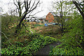
Commercial units at the end of Crow's Nest
A path has developed here though it is not a definitive route.
Image: © Bill Boaden
Taken: 4 Apr 2022
0.09 miles
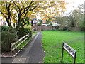
3
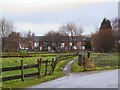
Short Cut
This footpath gives pedestrian access from Darcy Lever to Bradley Fold. On the 1940's O/S map, this housing estate does not yet exist, and the railway line would cross the view at this point.
Image: © Roger May
Taken: 21 Dec 2005
0.13 miles
4
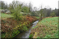
Blackshaw Brook
Looking downstream near Little Lever. The water flows towards the River Croal.
Image: © Bill Boaden
Taken: 4 Apr 2022
0.15 miles
5
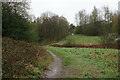
Path to Little Lever
Here it is crossing the valley of Blackshaw Brook.
Image: © Bill Boaden
Taken: 4 Apr 2022
0.15 miles
6
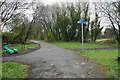
Footpath crossing near Bradley Fold
Cycle routes have been developed on the route of a former railway.
Image: © Bill Boaden
Taken: 4 Apr 2022
0.16 miles
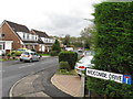
8
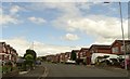
Brodick Drive
A residential street on a Breightmet housing estate.
Image: © philandju
Taken: 3 Aug 2020
0.25 miles