IMAGES TAKEN NEAR TO
Taylors Lane, BOLTON, BL2 6QS
Introduction
This page details the photographs taken nearby to Taylors Lane, BL2 6QS by members of the Geograph project.
The Geograph project started in 2005 with the aim of publishing, organising and preserving representative images for every square kilometre of Great Britain, Ireland and the Isle of Man.

There are currently over 7.5m images from over14,400 individuals and you can help contribute to the project by visiting https://www.geograph.org.uk
Image Map
Images are licensed for reuse under creativecommons.org/licenses/by-sa/2.0
Notes
- Clicking on the map will re-center to the selected point.
- The higher the marker number, the further away the image location is from the centre of the postcode.
Image Listing (32 Images Found)
Images are licensed for reuse under creativecommons.org/licenses/by-sa/2.0
Image
Details
Distance
1
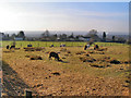
Farmland between Ainsworth and Breightmet
Image: © David Dixon
Taken: 6 Feb 2010
0.10 miles
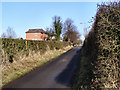
2
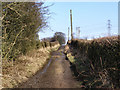
Ainsworth Hall Road
After passing the row of houses, the road becomes a farm track.
Image: © David Dixon
Taken: 6 Feb 2010
0.11 miles
3
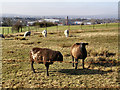
Sheep grazing
Farmland seen from Ainsworth Hall Road. The fields stretch towards Breightmet, and beyond that, Bolton is visible in the distance
Image: © David Dixon
Taken: 6 Feb 2010
0.12 miles
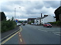
4
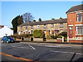
Bury Road
Terraced houses with gardens on the north side of Bury Road.
Image: © David Dixon
Taken: 6 Feb 2010
0.13 miles
5
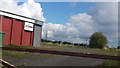
Ainsworth Hall Ground
The red building has changing facilities. The surrounding area is farmland.
Image: © Bradley Michael
Taken: 15 Sep 2015
0.13 miles
7
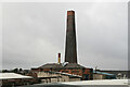
Ainsworth Mill chimney and engine house
This former finishing and dyeworks owned by the Ainsworth Finishing Company was derelict in 2009 but has since been adaptively reused. The building alongside the chimney was almost certainly an engine house for a horizontal engine. It had later had a chimney inserted in its roofline and presumably contained a more modern boiler.
Image: © Chris Allen
Taken: 11 Oct 2009
0.14 miles
8
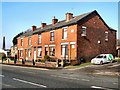
Terraced houses on Bury Road
A row of terraced houses on the north side of Bury Road. The plaque on the end house names the terrace as "South View"
Image: © David Dixon
Taken: 6 Feb 2010
0.14 miles
10
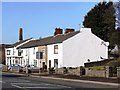
Top Bull
The Top Bull public house at the end of a row of terraced houses on Bury Road.
Image: © David Dixon
Taken: 6 Feb 2010
0.14 miles