IMAGES TAKEN NEAR TO
Milnthorpe Road, BOLTON, BL2 6PN
Introduction
This page details the photographs taken nearby to Milnthorpe Road, BL2 6PN by members of the Geograph project.
The Geograph project started in 2005 with the aim of publishing, organising and preserving representative images for every square kilometre of Great Britain, Ireland and the Isle of Man.

There are currently over 7.5m images from over14,400 individuals and you can help contribute to the project by visiting https://www.geograph.org.uk
Image Map
Images are licensed for reuse under creativecommons.org/licenses/by-sa/2.0
Notes
- Clicking on the map will re-center to the selected point.
- The higher the marker number, the further away the image location is from the centre of the postcode.
Image Listing (5 Images Found)
Images are licensed for reuse under creativecommons.org/licenses/by-sa/2.0
Image
Details
Distance
2
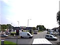
Supermarket at Breightmet on Bury Road
Image: © Raymond Knapman
Taken: 26 Jul 2012
0.17 miles
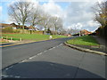
5
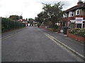
Strathmore Road, Breightmet, Bolton
A short cul-de-sac of pre second world war semi detached houses, once semi rural and now amidst a council estate.
Image: © philandju
Taken: 23 Sep 2011
0.22 miles