IMAGES TAKEN NEAR TO
Tarbet Drive, BOLTON, BL2 6LT
Introduction
This page details the photographs taken nearby to Tarbet Drive, BL2 6LT by members of the Geograph project.
The Geograph project started in 2005 with the aim of publishing, organising and preserving representative images for every square kilometre of Great Britain, Ireland and the Isle of Man.

There are currently over 7.5m images from over14,400 individuals and you can help contribute to the project by visiting https://www.geograph.org.uk
Image Map
Images are licensed for reuse under creativecommons.org/licenses/by-sa/2.0
Notes
- Clicking on the map will re-center to the selected point.
- The higher the marker number, the further away the image location is from the centre of the postcode.
Image Listing (13 Images Found)
Images are licensed for reuse under creativecommons.org/licenses/by-sa/2.0
Image
Details
Distance
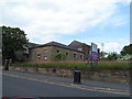
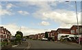
4
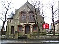
Breightmet Methodist
Solid stone church beside the A58 at Breightmet.
Image: © Roger May
Taken: 21 Dec 2005
0.15 miles
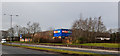
7
Disused Wesleyan Chapel - Breightmet
Image: © Anthony Parkes
Taken: 22 Jun 2014
0.20 miles
9
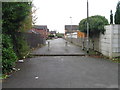
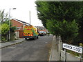
Brodick Drive
A residential street on a Breightmet housing estate.
Image: © philandju
Taken: 3 Aug 2020
0.22 miles
10
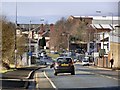
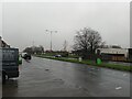
Bury Road
The A58 (Bury Road) approaching Breightmet.
Image: © David Dixon
Taken: 6 Feb 2010
0.23 miles