IMAGES TAKEN NEAR TO
Garstang Avenue, BOLTON, BL2 6ER
Introduction
This page details the photographs taken nearby to Garstang Avenue, BL2 6ER by members of the Geograph project.
The Geograph project started in 2005 with the aim of publishing, organising and preserving representative images for every square kilometre of Great Britain, Ireland and the Isle of Man.

There are currently over 7.5m images from over14,400 individuals and you can help contribute to the project by visiting https://www.geograph.org.uk
Image Map
Images are licensed for reuse under creativecommons.org/licenses/by-sa/2.0
Notes
- Clicking on the map will re-center to the selected point.
- The higher the marker number, the further away the image location is from the centre of the postcode.
Image Listing (7 Images Found)
Images are licensed for reuse under creativecommons.org/licenses/by-sa/2.0
Image
Details
Distance
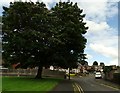
1
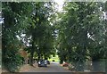
Slaidburn Avenue
On a Breightmet housing estate.
Image: © philandju
Taken: 3 Aug 2020
0.13 miles
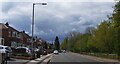
3
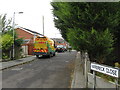
Langholm Drive
A residential cul de sac in Breightmet.
Image: © philandju
Taken: 3 Aug 2020
0.18 miles
5
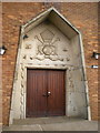
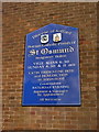
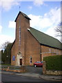
St Osmund Catholic Church, Doorway
Image: © Alexander P Kapp
Taken: 26 Mar 2009
0.22 miles