IMAGES TAKEN NEAR TO
Oakenbottom Road, BOLTON, BL2 6DN
Introduction
This page details the photographs taken nearby to Oakenbottom Road, BL2 6DN by members of the Geograph project.
The Geograph project started in 2005 with the aim of publishing, organising and preserving representative images for every square kilometre of Great Britain, Ireland and the Isle of Man.

There are currently over 7.5m images from over14,400 individuals and you can help contribute to the project by visiting https://www.geograph.org.uk
Image Map
Images are licensed for reuse under creativecommons.org/licenses/by-sa/2.0
Notes
- Clicking on the map will re-center to the selected point.
- The higher the marker number, the further away the image location is from the centre of the postcode.
Image Listing (14 Images Found)
Images are licensed for reuse under creativecommons.org/licenses/by-sa/2.0
Image
Details
Distance
1
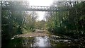
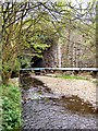
Bradshaw Brook, Oakenbottom Bridge
Footpath from Colenso Road in Tonge Fold along Oakenbottom Bridge here over Bradshaw Brook and into Leverhulme Park
Image: © John Westhead
Taken: 14 Apr 2020
0.12 miles
2
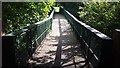
Footbridge over Bradshaw Brook
For the view of the brook see Image
Image: © Bradley Michael
Taken: 15 Sep 2015
0.12 miles
3
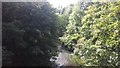
Bradshaw Brook from Breightmet
Taken from a footbridge - Image - linking Stanley Mews and Colenso Road, looking downstream. The brook is around a kilometre away from its confluence with the River Irwell.
Image: © Bradley Michael
Taken: 15 Sep 2015
0.13 miles
4
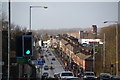
Bury Road, Breightmet
This is the A58 heading towards Bolton, though it becomes the northern ring road at the traffic lights ahead. The dip in the foreground is the valley of Bradshaw Brook.
Image: © Bill Boaden
Taken: 3 Dec 2011
0.19 miles
5
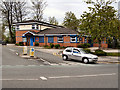
Breightmet Police Station
Blenheim Road, at the junction with Bury Road (A58)
Image: © David Dixon
Taken: 9 May 2010
0.19 miles
6
Bury Road
Bury Road (A58) at the junction with Crompton Way, at Tootill Bridge.
Image: © David Dixon
Taken: 9 May 2010
0.20 miles
7
Bradshaw Brook
Bradshaw Brook at Tootill Bridge, in the Seven Acres Local Nature Reserve.
Image: © David Dixon
Taken: 9 May 2010
0.21 miles
8

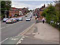
Terraced housing on Bury Road at Tonge Fold
Image: © Raymond Knapman
Taken: 26 Jul 2012
0.21 miles
9
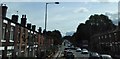
Bury Road
Approaching the junction with Crompton Way in Bolton.
Image: © philandju
Taken: 7 Aug 2017
0.22 miles
10
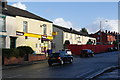
The Hare and Hounds, Breightmet
Another closed pub, but it may be undergoing refurbishment. The road is the A58 Bury Road.
Image: © Bill Boaden
Taken: 3 Dec 2011
0.22 miles