IMAGES TAKEN NEAR TO
Manor Gate Road, BOLTON, BL2 6AB
Introduction
This page details the photographs taken nearby to Manor Gate Road, BL2 6AB by members of the Geograph project.
The Geograph project started in 2005 with the aim of publishing, organising and preserving representative images for every square kilometre of Great Britain, Ireland and the Isle of Man.

There are currently over 7.5m images from over14,400 individuals and you can help contribute to the project by visiting https://www.geograph.org.uk
Image Map
Images are licensed for reuse under creativecommons.org/licenses/by-sa/2.0
Notes
- Clicking on the map will re-center to the selected point.
- The higher the marker number, the further away the image location is from the centre of the postcode.
Image Listing (18 Images Found)
Images are licensed for reuse under creativecommons.org/licenses/by-sa/2.0
Image
Details
Distance
1
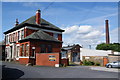
Breightmet Fold House
A surprisingly grand office building as part of the adjoining mill. Some of the units are now vacant.
Image: © Bill Boaden
Taken: 15 Jul 2012
0.08 miles
2
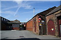
Industrial premises at Breightmet Fold
An old mill but appears still in use subject to adaptation. The business Fiber Mark states it has a research laboratory here.
Image: © Bill Boaden
Taken: 15 Jul 2012
0.11 miles
3
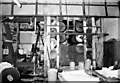
Textile finishing machinery, Red Bridge Mills, Ainsworth
This site was operated by Stephen Glaister Ltd until 1985 when the company was liquidated. It is believed the works has been demolished. The machinery is a set of cloth drying cylinder (or "tins") and it was driven by a small diagonal duplex steam engine, now scrapped. Photographed in operation.
Sadly, I didn't photograph the works.
Image: © Chris Allen
Taken: 15 Dec 1983
0.16 miles
4
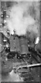
Steam engine, Red Bridge Mills, Ainsworth
Diagonal duplex steam engine by Duncan Stewart & Co (1902) Ltd of Glasgow. Swathed in steam from leaking glands, this was hard at work driving a set of drying cylinders for fabric. This was typical of the textile dyeing and finishing trades. Now long since scrapped - the works closed in 1985.
Image: © Chris Allen
Taken: 15 Dec 1983
0.16 miles
5
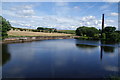
Mill reservoir at Breightmet Fold
It is now used for fishing by Radcliffe Angling Society.
Image: © Bill Boaden
Taken: 15 Jul 2012
0.17 miles
6
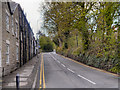
Red Lane
Looking up the hill at Red Lane, from Red Bridge.
Image: © David Dixon
Taken: 22 Apr 2012
0.19 miles
7
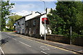
The Red Bridge
The pub is closed and boarded up. The bridge it is named after is on the right, also known as Middlebrook Bridge.
Image: © Bill Boaden
Taken: 15 Jul 2012
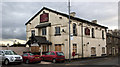
0.21 miles
8
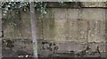
Old Boundary Marker by Red Lane/Bury Old Road, Bolton Parish
Parish Boundary Marker by the UC road, in parish of Bolton (Bolton District), Red Lane/Bury Old Road, Red Bridge parapet, South side of road.
Surveyed
Milestone Society National ID: LA_BOL07bpb
Image: © Philip Platt
Taken: Unknown
0.21 miles
10
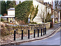
Red (or Middle Brook) Bridge
A modern road sign names this bridge, which carries Red Lane over Blackshaw Brook, "Red Bridge". However, the inscription in the stone bridge walls names it as "Middle Brook Bridge". The OS map uses both names (ie "Red Bridge or Middle Brook Bridge").
Image: © David Dixon
Taken: 13 Feb 2010
0.21 miles