IMAGES TAKEN NEAR TO
Knowsley Road, BOLTON, BL2 5PZ
Introduction
This page details the photographs taken nearby to Knowsley Road, BL2 5PZ by members of the Geograph project.
The Geograph project started in 2005 with the aim of publishing, organising and preserving representative images for every square kilometre of Great Britain, Ireland and the Isle of Man.

There are currently over 7.5m images from over14,400 individuals and you can help contribute to the project by visiting https://www.geograph.org.uk
Image Map
Images are licensed for reuse under creativecommons.org/licenses/by-sa/2.0
Notes
- Clicking on the map will re-center to the selected point.
- The higher the marker number, the further away the image location is from the centre of the postcode.
Image Listing (49 Images Found)
Images are licensed for reuse under creativecommons.org/licenses/by-sa/2.0
Image
Details
Distance
2
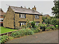
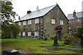
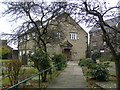
Hook's Cottage, Oaks Nook
This is Hook's Cottage, Oaks Nook; it is on the left-hand corner of the lane from Brown Hill Farm as it reaches Knowsley Road. The door lintel is inscribed "N/B.A/1773" which indicates that it was built by Nathan Brooks in 1773 at the same time as the church was enlarged. Nathan Brooks’ grave is in the church graveyard.
The cottage is a Grade II listed building (Historic England List Entry Number: 1067270 https://historicengland.org.uk/listing/the-list/list-entry/1067270 ).
Image: © David Dixon
Taken: 19 Aug 2020
0.03 miles
3
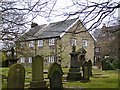
Hook's Cottage, Knowsley Road
Two contrasting properties tucked next to the Unitarian Church, in Knowsley Road. The cottage nearest to the camera is dated 1773; it must have been built when the church was enlarged.
It is a Grade II listed building (Historic England List Entry Number: 1067270 https://historicengland.org.uk/listing/the-list/list-entry/1067270 ).
Image: © David Dixon
Taken: 13 Feb 2010
0.03 miles
4
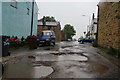
Puddly lane in Ainsworth
This is Victoria Street which provides important residential vehicle access.
Image: © Bill Boaden
Taken: 19 Sep 2010
0.03 miles
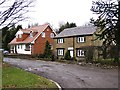
6
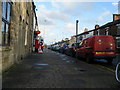
The Village Post Office
Post office on Church Street.
Image: © David Dixon
Taken: 13 Feb 2010
0.04 miles
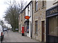
7
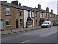
Church Street
Row of terraced houses with post office and dentist in the middle.
Image: © David Dixon
Taken: 13 Feb 2010
0.04 miles
8
Ainsworth Presbyterian Chapel (Unitarian)
Built 1715
Image: © Alexander P Kapp
Taken: 21 Oct 2005
0.04 miles
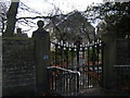
9
Ainsworth Presbyterian Church (Unitarian)
One of the oldest buildings in Ainsworth, the grade II listed church was built in 1715.
http://www.ainsworthunitarians.org.uk/
Image: © David Dixon
Taken: 13 Feb 2010
0.05 miles
10
The Presbyterian (Unitarian) Church, Knowsley Road
The Grade II listed Church in Knowsley Road is one of the oldest builtings in Ainsworth, dating from 1715.
http://www.ainsworthunitarians.org.uk/
Image: © David Dixon
Taken: 13 Feb 2010
0.05 miles