IMAGES TAKEN NEAR TO
Hopewell Close, BOLTON, BL2 5DR
Introduction
This page details the photographs taken nearby to Hopewell Close, BL2 5DR by members of the Geograph project.
The Geograph project started in 2005 with the aim of publishing, organising and preserving representative images for every square kilometre of Great Britain, Ireland and the Isle of Man.

There are currently over 7.5m images from over14,400 individuals and you can help contribute to the project by visiting https://www.geograph.org.uk
Image Map
Images are licensed for reuse under creativecommons.org/licenses/by-sa/2.0
Notes
- Clicking on the map will re-center to the selected point.
- The higher the marker number, the further away the image location is from the centre of the postcode.
Image Listing (40 Images Found)
Images are licensed for reuse under creativecommons.org/licenses/by-sa/2.0
Image
Details
Distance
1
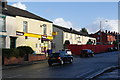
The Hare and Hounds, Breightmet
Another closed pub, but it may be undergoing refurbishment. The road is the A58 Bury Road.
Image: © Bill Boaden
Taken: 3 Dec 2011
0.04 miles
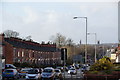
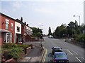
2
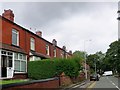
Empire Road
In Breightmet, a suburb of Bolton.
Image: © philandju
Taken: 26 Jul 2020
0.04 miles
3
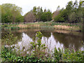
Lodge, Seven Acres
Disused lodge in the Seven Acres Local Nature Reserve; north of Bury Road.
Image: © David Dixon
Taken: 9 May 2010
0.05 miles
4
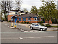
Breightmet Police Station
Blenheim Road, at the junction with Bury Road (A58)
Image: © David Dixon
Taken: 9 May 2010
0.07 miles
5
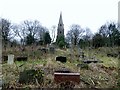
Burial ground at St. James', Breightmet
Somewhat overgrown with overturned and broken gravestones. The local newspaper has reported vandalism in the churchyard in 1998 and again in 2003.
Image: © philandju
Taken: 13 Dec 2013
0.07 miles
6
Bury Road, Breightmet
From here you can see Bolton Town Hall and Parish Church.
Image: © Bill Boaden
Taken: 3 Dec 2011
0.08 miles
7
Lych gate at St. James', Breightmet
C. of E. church in a suburb of Bolton.
Image: © philandju
Taken: 13 Dec 2013
0.08 miles
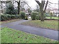
9
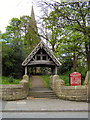
St James' Church, Breightmet
The lychgate, with the church behind it.
Image: © David Dixon
Taken: 9 May 2010
0.09 miles
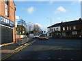
10
Empire Road joins Bury Road at Breightmet
Empire Road on left of view
Image: © Raymond Knapman
Taken: 26 Jul 2012
0.09 miles