IMAGES TAKEN NEAR TO
New Lane, BOLTON, BL2 5BZ
Introduction
This page details the photographs taken nearby to New Lane, BL2 5BZ by members of the Geograph project.
The Geograph project started in 2005 with the aim of publishing, organising and preserving representative images for every square kilometre of Great Britain, Ireland and the Isle of Man.

There are currently over 7.5m images from over14,400 individuals and you can help contribute to the project by visiting https://www.geograph.org.uk
Image Map
Images are licensed for reuse under creativecommons.org/licenses/by-sa/2.0
Notes
- Clicking on the map will re-center to the selected point.
- The higher the marker number, the further away the image location is from the centre of the postcode.
Image Listing (9 Images Found)
Images are licensed for reuse under creativecommons.org/licenses/by-sa/2.0
Image
Details
Distance
1
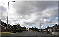
New Lane
Residential street in Breightmet, Bolton.
Image: © philandju
Taken: 26 Sep 2022
0.02 miles
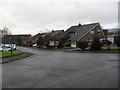
2
New Lane, Breightmet
A residential road comprising a mix of old stone cottages, council houses and modern private houses.
Image: © philandju
Taken: 23 Sep 2011
0.03 miles
4
New Lane becomes Stitch - Mi - Lane
At Bottom o' th' Moor.
Image: © philandju
Taken: 26 Sep 2022
0.06 miles
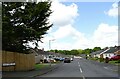
5
Rusland Drive
1970s houses in Harwood.
Image: © Burgess Von Thunen
Taken: 4 Feb 2013
0.09 miles
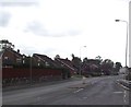
6
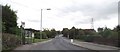
Stitch - Mi - Lane, Breightmet, Bolton
The lower end of the lane at the corner where the road becomes New Lane.
Image: © philandju
Taken: 23 Sep 2011
0.11 miles
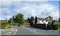
7
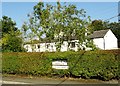
Cottages at Bottom o' th' Moor
Once a remote hamlet, Bottom o' th' Moor is now surrounded by a modern housing estate.
Image: © philandju
Taken: 21 Sep 2020
0.17 miles
8
Stitch-Mi-Lane, Harwood
Taking a Sunday morning walk on the last day of February 2021.
Image: © philandju
Taken: 28 Feb 2021
0.18 miles
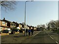
9

South Drive, Harwood
A Sunday morning in late February.
Image: © philandju
Taken: 28 Feb 2021
0.23 miles