IMAGES TAKEN NEAR TO
Tottington Road, BOLTON, BL2 4DW
Introduction
This page details the photographs taken nearby to Tottington Road, BL2 4DW by members of the Geograph project.
The Geograph project started in 2005 with the aim of publishing, organising and preserving representative images for every square kilometre of Great Britain, Ireland and the Isle of Man.

There are currently over 7.5m images from over14,400 individuals and you can help contribute to the project by visiting https://www.geograph.org.uk
Image Map
Images are licensed for reuse under creativecommons.org/licenses/by-sa/2.0
Notes
- Clicking on the map will re-center to the selected point.
- The higher the marker number, the further away the image location is from the centre of the postcode.
Image Listing (31 Images Found)
Images are licensed for reuse under creativecommons.org/licenses/by-sa/2.0
Image
Details
Distance
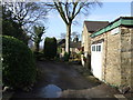
2
Footpath leading to a ruined farm
The path descends from farmland and past the now ruined Hill Farm.
Image: © Phil Platt
Taken: 2 Apr 2011
0.06 miles
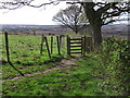
4
Hill Farm
In ruins. The farm was abandoned in the 1970s, and 30 odd years on, not much remains.
Image: © Phil Platt
Taken: 2 Apr 2011
0.08 miles
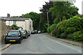
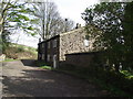
5
Riding Gate
A hamlet off Tottington Road, Harwood.
Image: © Phil Platt
Taken: 2 Apr 2011
0.09 miles
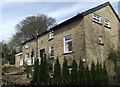
6
Cottage at Lower Knotts
Close to Riding Gate. About six cottages make up the hamlet.
Image: © Phil Platt
Taken: 2 Apr 2011
0.11 miles
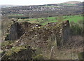
7
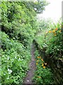
Footpath above Harwood Quarry
Somewhat overgrown as plant growth burgeons.
Image: © philandju
Taken: 27 May 2014
0.11 miles
8
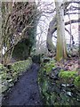
Muddy footpath near Lower Knotts
The path connects the cottages at Lower Knotts with Riding Gate.
Image: © philandju
Taken: 10 Jan 2018
0.13 miles
10
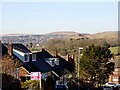
A view of Cheetham Close
From Davenport Fold Road in Harwood. Cheetham Close is the rounded hill in the right of centre background. The hill to the right midground is part of the landscaping of filled in parts of Harwood Quarry.
Image: © philandju
Taken: 1 Mar 2021
0.14 miles