IMAGES TAKEN NEAR TO
Tottington Road, BOLTON, BL2 4BW
Introduction
This page details the photographs taken nearby to Tottington Road, BL2 4BW by members of the Geograph project.
The Geograph project started in 2005 with the aim of publishing, organising and preserving representative images for every square kilometre of Great Britain, Ireland and the Isle of Man.

There are currently over 7.5m images from over14,400 individuals and you can help contribute to the project by visiting https://www.geograph.org.uk
Image Map
Images are licensed for reuse under creativecommons.org/licenses/by-sa/2.0
Notes
- Clicking on the map will re-center to the selected point.
- The higher the marker number, the further away the image location is from the centre of the postcode.
Image Listing (60 Images Found)
Images are licensed for reuse under creativecommons.org/licenses/by-sa/2.0
Image
Details
Distance
1
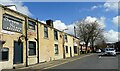
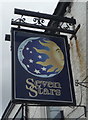
Road closed
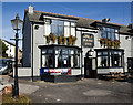
Tottington Road in Harwood is closed for resurfacing work. The scaffolding on the left is to facilitate the sandblasting of the stonework of the Seven Stars pub.
Image: © philandju
Taken: 16 Apr 2021
0.10 miles
2
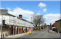
Recreation Street
An unadopted street in Harwood.
Image: © philandju
Taken: 16 Apr 2021
0.10 miles
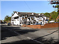
3
The Grey Mare Inn
A pub on Tottington Road.
Image: © philandju
Taken: 31 May 2021
0.11 miles
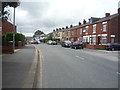
4
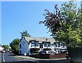
Tottington Road and the Seven Stars pub
In Harwood, north Bolton.
Image: © philandju
Taken: 15 Apr 2023
0.11 miles
5
Grey Mare Inn
Tottington Road, Bradshaw.
Image: © David Dixon
Taken: 17 May 2010
0.11 miles
6

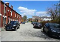
Recreation ground
Play area off Recreation Street in Harwood.
Image: © philandju
Taken: 16 Apr 2021
0.11 miles
9
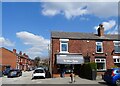
The Village Pantry
A sandwich shop in Harwood.
Image: © philandju
Taken: 16 Apr 2021
0.12 miles