IMAGES TAKEN NEAR TO
Briery Avenue, BOLTON, BL2 4AJ
Introduction
This page details the photographs taken nearby to Briery Avenue, BL2 4AJ by members of the Geograph project.
The Geograph project started in 2005 with the aim of publishing, organising and preserving representative images for every square kilometre of Great Britain, Ireland and the Isle of Man.

There are currently over 7.5m images from over14,400 individuals and you can help contribute to the project by visiting https://www.geograph.org.uk
Image Map
Images are licensed for reuse under creativecommons.org/licenses/by-sa/2.0
Notes
- Clicking on the map will re-center to the selected point.
- The higher the marker number, the further away the image location is from the centre of the postcode.
Image Listing (13 Images Found)
Images are licensed for reuse under creativecommons.org/licenses/by-sa/2.0
Image
Details
Distance
1
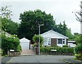
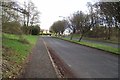
New Heys Way becomes Catterall Crescent
A residential area in Harwood.
Image: © philandju
Taken: 28 Jul 2020
0.12 miles
2
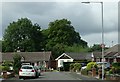
New Heys Way
A residential area in Harwood.
Image: © philandju
Taken: 28 Jul 2020
0.13 miles
3
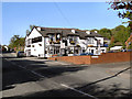
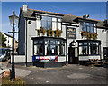
Grey Mare Inn
Tottington Road, Bradshaw.
Image: © David Dixon
Taken: 17 May 2010
0.21 miles
5
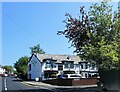
The Grey Mare Inn
A pub on Tottington Road.
Image: © philandju
Taken: 31 May 2021
0.21 miles
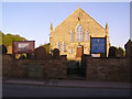
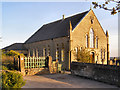
9
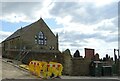
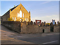
Primitive Methodist Chapel
The chapel, on Tottington Road, was built in 1890. The building is no longer in use as a chapel and seems to be currently undergoing a conversion, probably to apartments.
Image: © philandju
Taken: 22 Apr 2022
0.23 miles