IMAGES TAKEN NEAR TO
Beech Close, BOLTON, BL2 3EB
Introduction
This page details the photographs taken nearby to Beech Close, BL2 3EB by members of the Geograph project.
The Geograph project started in 2005 with the aim of publishing, organising and preserving representative images for every square kilometre of Great Britain, Ireland and the Isle of Man.

There are currently over 7.5m images from over14,400 individuals and you can help contribute to the project by visiting https://www.geograph.org.uk
Image Map
Images are licensed for reuse under creativecommons.org/licenses/by-sa/2.0
Notes
- Clicking on the map will re-center to the selected point.
- The higher the marker number, the further away the image location is from the centre of the postcode.
Image Listing (32 Images Found)
Images are licensed for reuse under creativecommons.org/licenses/by-sa/2.0
Image
Details
Distance
1
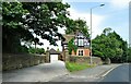
Former gatehouse
The house on Turton Road was originally the gatehouse to the now demolished Birtenshaw Hall.
Image: © philandju
Taken: 28 Jun 2021
0.13 miles
2
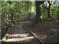
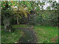
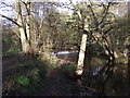
Footpath in Bradshaw
The path leads from Rigby Lane, crosses Bradshaw Brook and joins Bradshaw Road.
Image: © philandju
Taken: 28 Oct 2011
0.15 miles
3
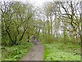
Rigby Lane
No more than a path as it climbs out of the valley of Bradshaw Brook
Image: © Kevin Waterhouse
Taken: 23 Apr 2024
0.16 miles
6
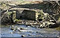
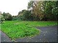
Outlet into Bradshaw Brook
Probably a long disused sewer outlet from the now demolished Bradshaw Hall, which stood at the top of the river bank here.
Image: © philandju
Taken: 15 Apr 2021
0.18 miles
7
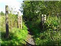
Redundant gatepost
Several decades ago the land on either side of the path was pasture belonging to Great Oaks Farm. To the right of this picture the Bolton to Blackburn railway ran atop an embankment and to allow the farmer to move his animals from one field to another there was a track under a bridge carrying the railway. The field to the right of the railway is no more and houses have been built there. The bridge has therefore been stopped up and is no longer visible. I suspect that this gatepost marks where the bridge/underpass was. The gate bracket suggests that the gate was to the left hand field and the slight indentation on the map of the railway embankment on the right of the railway also suggests a bridge and track under it.
Image: © philandju
Taken: 14 Sep 2020
0.19 miles
8
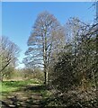
Upper Bradshaw Valley Nature Trail
A trail well used by local residents.
Image: © philandju
Taken: 15 Apr 2021
0.19 miles
9
Bradshaw Brook, Bradshaw
Upstream from the Rigby Lane crossing there is this small weir.
Image: © philandju
Taken: 28 Oct 2011
0.19 miles
10
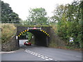
Low Bridge
This 14 foot high railway bridge carries the Manchester to Blackburn line.
The bridge is located at the busy junction of the B6472 and the B6391.
Image: © Paul Anderson
Taken: 23 Sep 2007
0.20 miles