IMAGES TAKEN NEAR TO
Printers Lane, BOLTON, BL2 3DW
Introduction
This page details the photographs taken nearby to Printers Lane, BL2 3DW by members of the Geograph project.
The Geograph project started in 2005 with the aim of publishing, organising and preserving representative images for every square kilometre of Great Britain, Ireland and the Isle of Man.

There are currently over 7.5m images from over14,400 individuals and you can help contribute to the project by visiting https://www.geograph.org.uk
Image Map
Images are licensed for reuse under creativecommons.org/licenses/by-sa/2.0
Notes
- Clicking on the map will re-center to the selected point.
- The higher the marker number, the further away the image location is from the centre of the postcode.
Image Listing (24 Images Found)
Images are licensed for reuse under creativecommons.org/licenses/by-sa/2.0
Image
Details
Distance
1
Long Meadow, Bromley Cross, Bolton
A Supplemental to http://www.geograph.org.uk/photo/1607415
Image: © John Fielding
Taken: 21 Feb 2009
0.09 miles
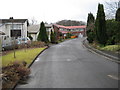
2
Long Meadow, Bromley Cross, Bolton
Long Meadow is part of a small estate of detached houses developed in the mid 1970s. Several of the houses have been extended. Some extensions are incompatible with the character and scale of the original estate development. For another view see http://www.geograph.org.uk/photo/1607424
Image: © John Fielding
Taken: 21 Feb 2009
0.09 miles
3
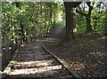
Footpath by Bradshaw Brook
The path runs through the Bradshaw Valley Nature Reserve.
Image: © philandju
Taken: 2 Feb 2013
0.10 miles
4
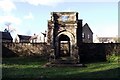
Bradshaw Hall porch
This Jacobean porch is all that remains of Bradshaw Hall, the home of the Bradshaw family from the 12th to the 18th century. Later occupants, the Lomaxes and the Hardcastles developed a bleachworks on the site. The bleachworks in turn is no longer, and has been converted into apartments and houses.
Image: © philandju
Taken: 2 Feb 2013
0.16 miles
5
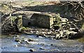
Outlet into Bradshaw Brook
Probably a long disused sewer outlet from the now demolished Bradshaw Hall, which stood at the top of the river bank here.
Image: © philandju
Taken: 15 Apr 2021
0.17 miles
6
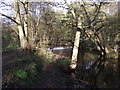
Bradshaw Brook, Bradshaw
Upstream from the Rigby Lane crossing there is this small weir.
Image: © philandju
Taken: 28 Oct 2011
0.21 miles
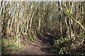
7
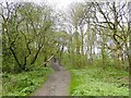
Footpath in Bradshaw
The path leads from Rigby Lane, crosses Bradshaw Brook and joins Bradshaw Road.
Image: © philandju
Taken: 28 Oct 2011
0.23 miles
8
Rigby Lane
No more than a path as it climbs out of the valley of Bradshaw Brook
Image: © Kevin Waterhouse
Taken: 23 Apr 2024
0.23 miles
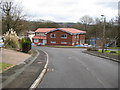
9
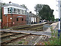
Bromley Cross railway station
The Bolton commuter town of Bromley Cross has a railway station served by the Northern Rail 'Ribble Valley' line.
The station is just south of the point where the two lines merge into one.
The single line continues on north through to Image
Image: © Paul Anderson
Taken: 23 Sep 2007
0.23 miles
10
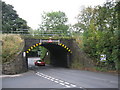
Low Bridge
This 14 foot high railway bridge carries the Manchester to Blackburn line.
The bridge is located at the busy junction of the B6472 and the B6391.
Image: © Paul Anderson
Taken: 23 Sep 2007
0.24 miles