IMAGES TAKEN NEAR TO
Staton Avenue, BOLTON, BL2 2SR
Introduction
This page details the photographs taken nearby to Staton Avenue, BL2 2SR by members of the Geograph project.
The Geograph project started in 2005 with the aim of publishing, organising and preserving representative images for every square kilometre of Great Britain, Ireland and the Isle of Man.

There are currently over 7.5m images from over14,400 individuals and you can help contribute to the project by visiting https://www.geograph.org.uk
Image Map
Images are licensed for reuse under creativecommons.org/licenses/by-sa/2.0
Notes
- Clicking on the map will re-center to the selected point.
- The higher the marker number, the further away the image location is from the centre of the postcode.
Image Listing (20 Images Found)
Images are licensed for reuse under creativecommons.org/licenses/by-sa/2.0
Image
Details
Distance
2
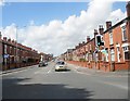
Bury Road
Approaching the junction with Crompton Way in Bolton.
Image: © philandju
Taken: 7 Aug 2017
0.11 miles
3

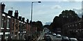
Terraced housing on Bury Road at Tonge Fold
Image: © Raymond Knapman
Taken: 26 Jul 2012
0.12 miles
4
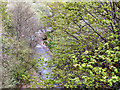
Bradshaw Brook
Bradshaw Brook, in the Seven Acres Local Nature Reserve, viewed from Tootill Bridge.
Image: © David Dixon
Taken: 9 May 2010
0.12 miles
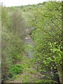
5
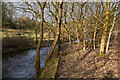
Bradshaw Brook in Seven Acres nature reserve
Image: © Ian Greig
Taken: 27 Feb 2015
0.13 miles
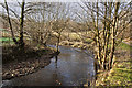
6
Bradshaw Brook
Looking along Bradshaw Brook in the Seven Acres Local Nature Reserve, from Tootill Bridge.
Image: © David Dixon
Taken: 9 May 2010
0.13 miles
7
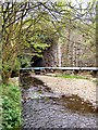
Bradshaw Brook
Bradshaw Brook at Tootill Bridge, in the Seven Acres Local Nature Reserve.
Image: © David Dixon
Taken: 9 May 2010
0.14 miles
8
Bury Road
Bury Road (A58) at the junction with Crompton Way, at Tootill Bridge.
Image: © David Dixon
Taken: 9 May 2010
0.14 miles
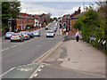
10

Bury Road
At the junction with Tonge Old Road. The building at the junction is Trinity Methodist Church.
Image: © philandju
Taken: 3 Aug 2021
0.16 miles