IMAGES TAKEN NEAR TO
Firwood Grove, BOLTON, BL2 2NY
Introduction
This page details the photographs taken nearby to Firwood Grove, BL2 2NY by members of the Geograph project.
The Geograph project started in 2005 with the aim of publishing, organising and preserving representative images for every square kilometre of Great Britain, Ireland and the Isle of Man.

There are currently over 7.5m images from over14,400 individuals and you can help contribute to the project by visiting https://www.geograph.org.uk
Image Map
Images are licensed for reuse under creativecommons.org/licenses/by-sa/2.0
Notes
- Clicking on the map will re-center to the selected point.
- The higher the marker number, the further away the image location is from the centre of the postcode.
Image Listing (18 Images Found)
Images are licensed for reuse under creativecommons.org/licenses/by-sa/2.0
Image
Details
Distance
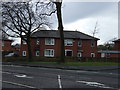
1
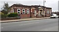
Tonge Moor Urban Care & Neighbourhood Centre on east side of Tonge Moor Road
Image: © Luke Shaw
Taken: 7 Sep 2024
0.06 miles
2
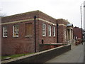
Tonge Moor Branch Library building
Now Tonge Moor Community Housing Office.
Image: © Margaret Clough
Taken: 6 Feb 2006
0.07 miles
3
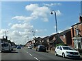
Tonge Moor Road
A road connecting Bradshaw with Bolton town centre.
Image: © philandju
Taken: 3 Aug 2021
0.09 miles
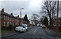
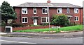
6
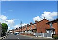
Terraced housing
On Thicketford Road in the Tonge Moor district of Bolton.
Image: © philandju
Taken: 15 May 2023
0.15 miles
7
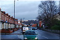
Thicketford Road, Tonge Moor
Ahead are buildings on the other side of Bradshaw Brook.
Image: © Bill Boaden
Taken: 17 Dec 2011
0.16 miles
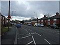
10
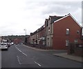
Thicketford Road, Bolton
Terraced houses line this drab street near the town centre.
Image: © philandju
Taken: 23 Sep 2011
0.17 miles