IMAGES TAKEN NEAR TO
Bury New Road, BOLTON, BL2 2BN
Introduction
This page details the photographs taken nearby to Bury New Road, BL2 2BN by members of the Geograph project.
The Geograph project started in 2005 with the aim of publishing, organising and preserving representative images for every square kilometre of Great Britain, Ireland and the Isle of Man.

There are currently over 7.5m images from over14,400 individuals and you can help contribute to the project by visiting https://www.geograph.org.uk
Image Map
Images are licensed for reuse under creativecommons.org/licenses/by-sa/2.0
Notes
- Clicking on the map will re-center to the selected point.
- The higher the marker number, the further away the image location is from the centre of the postcode.
Image Listing (63 Images Found)
Images are licensed for reuse under creativecommons.org/licenses/by-sa/2.0
Image
Details
Distance
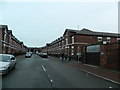
1
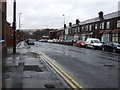
Castle Street (B6209), Bolton
Heading north west.
Image: © JThomas
Taken: 28 Mar 2015
0.07 miles
2
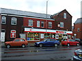
Post Office and store, Castle Street, Bolton
Image: © JThomas
Taken: 28 Mar 2015
0.08 miles
3
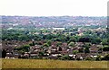
A view of Bolton from Harwood
Centre and towards the horizon the town hall clock tower can be seen, and to its left, St. Peter's Church - Bolton Parish Church.
Image: © philandju
Taken: 3 Jun 2022
0.08 miles
5
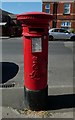
King Edward VII postbox
On Castle Street, Bolton.
Image: © philandju
Taken: 3 Jul 2018
0.10 miles
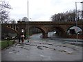
7
Croal Viaduct - 2
Detail of one of the masonry arches looking through to Dorset Street.
Image: © Alan Murray-Rust
Taken: 25 Jul 2012
0.12 miles
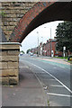
9
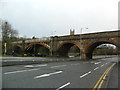
Viaduct over Bury New Rd, Bolton
St Peter's Church tower in the background.
Image: © John Lord
Taken: 26 Dec 2012
0.13 miles
10
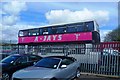
The Dancing Bus
Transport for A-Jays Cheerleaders
Image: © Anthony Parkes
Taken: 27 Apr 2012
0.13 miles