IMAGES TAKEN NEAR TO
The Grove, BOLTON, BL2 1LZ
Introduction
This page details the photographs taken nearby to The Grove, BL2 1LZ by members of the Geograph project.
The Geograph project started in 2005 with the aim of publishing, organising and preserving representative images for every square kilometre of Great Britain, Ireland and the Isle of Man.

There are currently over 7.5m images from over14,400 individuals and you can help contribute to the project by visiting https://www.geograph.org.uk
Image Map
Images are licensed for reuse under creativecommons.org/licenses/by-sa/2.0
Notes
- Clicking on the map will re-center to the selected point.
- The higher the marker number, the further away the image location is from the centre of the postcode.
Image Listing (27 Images Found)
Images are licensed for reuse under creativecommons.org/licenses/by-sa/2.0
Image
Details
Distance
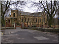
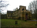
3
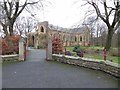
St. Stephen and All Martyrs, Lever Bridge
Church of England parish church.
Image: © philandju
Taken: 19 Dec 2013
0.19 miles
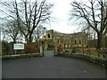
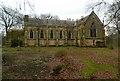
4
St. Stephen and All Martyrs, Lever Bridge
To the right is the war memorial to the fallen of the parish in the two world wars of the twentieth century.
Image: © philandju
Taken: 19 Dec 2013
0.19 miles
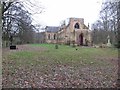
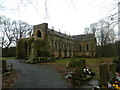
5
The Church of St Stephen & All Martyrs, Lever Bridge
See Image] for close-up detail.
Image: © David Dixon
Taken: 14 Feb 2010
0.19 miles
7
Church of St Stephen & All Martyrs, Lever Bridge
Image: © John Lord
Taken: 26 Dec 2012
0.19 miles
8
Church of St Stephen & All Martyrs, Lever Bridge
Image: © John Lord
Taken: 26 Dec 2012
0.19 miles
9
Church of St Stephen & All Martyrs, Lever Bridge
Image: © John Lord
Taken: 26 Dec 2012
0.19 miles
10
Church of St Stephen & All Martyrs, Lever Bridge
Image: © John Lord
Taken: 26 Dec 2012
0.19 miles