IMAGES TAKEN NEAR TO
Manchester Road, BOLTON, BL2 1ET
Introduction
This page details the photographs taken nearby to Manchester Road, BL2 1ET by members of the Geograph project.
The Geograph project started in 2005 with the aim of publishing, organising and preserving representative images for every square kilometre of Great Britain, Ireland and the Isle of Man.

There are currently over 7.5m images from over14,400 individuals and you can help contribute to the project by visiting https://www.geograph.org.uk
Image Map
Images are licensed for reuse under creativecommons.org/licenses/by-sa/2.0
Notes
- Clicking on the map will re-center to the selected point.
- The higher the marker number, the further away the image location is from the centre of the postcode.
Image Listing (129 Images Found)
Images are licensed for reuse under creativecommons.org/licenses/by-sa/2.0
Image
Details
Distance
1
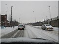
Snow on the roads
Took this out the front windscreen when the traffic stopped near the Station in Bolton
Image: © Bill Nicholls
Taken: 20 Dec 2009
0.02 miles
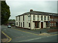
2
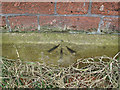
Pivot Bench Mark
Pivot Bench Mark: Bolton, Rose Hill Tavern Mark on coping of wall of Rose-hill Tavern, at corner of Lever-street ; 1.01 ft. above surface [1GL, Preston to Manchester, Mark No. 58] estimated location.
This bench mark was used during the First primary levelling, England & Wales, and was levelled with a height of 301.1680 feet [91.7960 metres] above mean sea level (Liverpool datum). It was included on the Preston to Manchester levelling line. The surveyor's description was No. 58. Mark on coping of wall of Rose-hill Tavern, at corner of Lever-street ; 1.01 ft. above surface (p431)
Image: © Ian Charters
Taken: 5 Apr 2010
0.08 miles
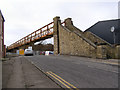
3
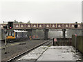
Orlando Bridge
From Bolton (Trinity Street) Station
Image: © David Dixon
Taken: 17 Aug 2010
0.08 miles
4
Orlando Road Bridge
The bridge carrying Orlando Road over the railway
Image: © David Dixon
Taken: 14 Feb 2010
0.08 miles
5
Orlando Street Bridge
Viewed from Lever Street Footbridge.
Image: © Bradley Michael
Taken: 18 Jun 2013
0.09 miles
6
Foot bridge, Rose Hill
Footbridge across the railway at Rose Hill.
Image: © David Dixon
Taken: 14 Feb 2010
0.09 miles
8
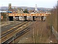
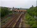
Bolton (Trinity Street) railway station, Greater Manchester, 2012
Opened in 1838 by the Manchester and Bolton Railway, later part of the Lancashire & Yorkshire Railway. The name included "Trinity Street" from 1895 to 1968. The main entrance building was replaced in 1987.
View north west from Orlando Street overbridge a few years before the line was electrified. For an updated view, see Image
Image: © Nigel Thompson
Taken: 17 Nov 2012
0.11 miles
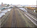
9
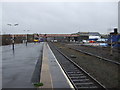
Bolton Railway Station
Line heading south east towards Manchester.
Image: © JThomas
Taken: 28 Mar 2015
0.11 miles
10
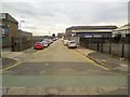
Moncrieffe Street
Off Orlando Street.
Image: © Gerald England
Taken: 24 Sep 2016
0.12 miles