IMAGES TAKEN NEAR TO
Sandileigh Drive, BOLTON, BL1 8UY
Introduction
This page details the photographs taken nearby to Sandileigh Drive, BL1 8UY by members of the Geograph project.
The Geograph project started in 2005 with the aim of publishing, organising and preserving representative images for every square kilometre of Great Britain, Ireland and the Isle of Man.

There are currently over 7.5m images from over14,400 individuals and you can help contribute to the project by visiting https://www.geograph.org.uk
Image Map
Images are licensed for reuse under creativecommons.org/licenses/by-sa/2.0
Notes
- Clicking on the map will re-center to the selected point.
- The higher the marker number, the further away the image location is from the centre of the postcode.
Image Listing (59 Images Found)
Images are licensed for reuse under creativecommons.org/licenses/by-sa/2.0
Image
Details
Distance
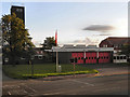
1
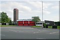
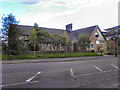
Bolton North fire station
Bolton North fire station, Crompton Way, Bolton, Greater Manchester
Image: © Kevin Hale
Taken: 3 Jun 2009
0.02 miles
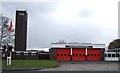
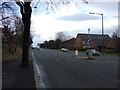
2
Fire station in Hall i' th' Wood
On Crompton Way.
Image: © philandju
Taken: 5 May 2022
0.03 miles
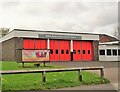
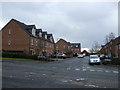
4
Fire Station, Crompton Way.
North Bolton Fire Station, on Crompton Way, Hall i' th' Wood.
Image: © David Dixon
Taken: 29 Aug 2010
0.04 miles
7
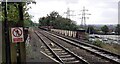
Railway heading south from Hall i' th' Wood Station
Image: © Luke Shaw
Taken: 7 Sep 2024
0.13 miles
10
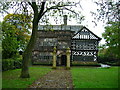
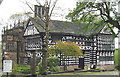
Hall i' th' Wood
The view from the south clearly shows the 1648 extension to the original Tudor building.
Image: © John H Darch
Taken: 27 Oct 2006
0.14 miles