IMAGES TAKEN NEAR TO
Sunnymead Avenue, BOLTON, BL1 8TG
Introduction
This page details the photographs taken nearby to Sunnymead Avenue, BL1 8TG by members of the Geograph project.
The Geograph project started in 2005 with the aim of publishing, organising and preserving representative images for every square kilometre of Great Britain, Ireland and the Isle of Man.

There are currently over 7.5m images from over14,400 individuals and you can help contribute to the project by visiting https://www.geograph.org.uk
Image Map
Images are licensed for reuse under creativecommons.org/licenses/by-sa/2.0
Notes
- Clicking on the map will re-center to the selected point.
- The higher the marker number, the further away the image location is from the centre of the postcode.
Image Listing (25 Images Found)
Images are licensed for reuse under creativecommons.org/licenses/by-sa/2.0
Image
Details
Distance
1
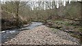
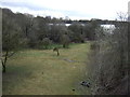
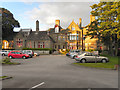
Eagley Brook & Barley Brook, Masons Clough
Barley Brook on the right meets with the Eagley Brook at Masons Clough near Hall i' th' Wood
Image: © John Westhead
Taken: 9 Apr 2020
0.06 miles
3
The Watermillock
This Grade II listed building, on Crompton Way, was built around 1880. It is currently in use as a pub/restaurant.
Image: © David Dixon
Taken: 29 Aug 2010
0.09 miles
4
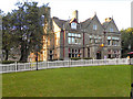
Toby Carvery (The Watermillock)
This grade II listed building, on Crompton Way, was built around 1880. It is now a pub/restaurant.
Image: © David Dixon
Taken: 29 Aug 2010
0.10 miles
5
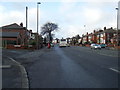
Crompton Way
The A58 ring road at Astley Bridge. The stone house to the left of the photo. was originally the gatehouse to Watermillock House on the other side of the road.
Image: © philandju
Taken: 1 Apr 2022
0.12 miles
6
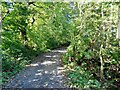
Yew Tree Lane
Leading from Yew Tree Farm to Ashworth Lane.
Image: © philandju
Taken: 27 Sep 2020
0.21 miles
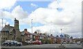
7
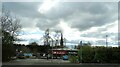
Shops off Crompton Way
A small retail development in Astley Bridge. The spire of St. Paul's C. of E. church is in the background.
Image: © philandju
Taken: 1 Apr 2022
0.21 miles
8
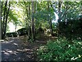
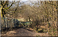
Yew Tree Lane at Doctor's Clough
The path joining the lane to the right leads to Mason Clough and the confluence of Eagley Brook and Barley Brook.
Image: © philandju
Taken: 27 Sep 2020
0.21 miles