IMAGES TAKEN NEAR TO
Astley Street, BOLTON, BL1 8EY
Introduction
This page details the photographs taken nearby to Astley Street, BL1 8EY by members of the Geograph project.
The Geograph project started in 2005 with the aim of publishing, organising and preserving representative images for every square kilometre of Great Britain, Ireland and the Isle of Man.

There are currently over 7.5m images from over14,400 individuals and you can help contribute to the project by visiting https://www.geograph.org.uk
Image Map (Loading...)


Getting Data...Please wait
Leaflet Map data © OpenStreetMap
Images are licensed for reuse under creativecommons.org/licenses/by-sa/2.0
Notes
- Clicking on the map will re-center to the selected point.
- The higher the marker number, the further away the image location is from the centre of the postcode.
Image Listing (13 Images Found)
Images are licensed for reuse under creativecommons.org/licenses/by-sa/2.0
Image
Details
Distance
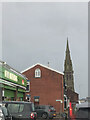
1
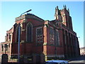
All Souls church
The school building belonging to this church is now an Islamic centre.
Image: © Margaret Clough
Taken: 9 Feb 2006
0.07 miles
2
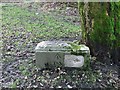
Old Boundary Marker north of Chapelfield Street, Bolton Parish
Parish Boundary Marker by the UC road, in parish of Bolton (Bolton District), North end of Chapelfield Street, on green under tree.
Surveyed
Milestone Society National ID: LA_BOL03pb
Image: © Philip Platt
Taken: Unknown
0.15 miles
4
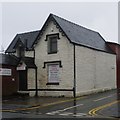
Old Toll House by Halliwell Road, Bolton
Toll House, No. 259, Halliwell Road (A6099).
To be surveyed
Milestone Society National ID: MA.BOL02
Image: © Milestone Society
Taken: Unknown
0.16 miles
5
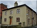
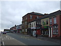
Houses in Astley Bridge
This building, which is Grade 2 listed, stands on the corner of Blackburn Road and Eckersley Road. It consists of 2 houses.
Image: © philandju
Taken: 13 Mar 2019
0.17 miles
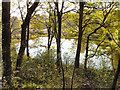
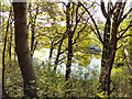
7
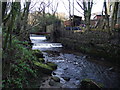
Weirs on Astley Brook
At this point the brook runs by the rear gardens of Sharples Vale Cottages.
Image: © philandju
Taken: 22 Dec 2011
0.21 miles
8
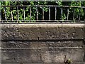
Old Boundary Marker on Astley Bridge by the A666, Bolton
Parish Boundary Marker by the A666, in parish of Bolton (Bolton District), Astley Bridge, in parapet, East side of road.
Inscription reads:-
ASTLEY BRIDGE
Surveyed
Milestone Society National ID: LA_PSBO17pb
Image: © Philip Platt
Taken: Unknown
0.23 miles
9
Lodge Below Astley Bridge Cemetery
Looking down towards the lodge from Astley Lane.
Image: © David Dixon
Taken: 19 Apr 2011
0.23 miles
10
Lodge Below Astley Bridge Cemetery
Looking down towards the lodge from Astley Lane.
Image: © David Dixon
Taken: 19 Apr 2011
0.23 miles