IMAGES TAKEN NEAR TO
Bramley Road, BOLTON, BL1 7RW
Introduction
This page details the photographs taken nearby to Bramley Road, BL1 7RW by members of the Geograph project.
The Geograph project started in 2005 with the aim of publishing, organising and preserving representative images for every square kilometre of Great Britain, Ireland and the Isle of Man.

There are currently over 7.5m images from over14,400 individuals and you can help contribute to the project by visiting https://www.geograph.org.uk
Image Map
Images are licensed for reuse under creativecommons.org/licenses/by-sa/2.0
Notes
- Clicking on the map will re-center to the selected point.
- The higher the marker number, the further away the image location is from the centre of the postcode.
Image Listing (30 Images Found)
Images are licensed for reuse under creativecommons.org/licenses/by-sa/2.0
Image
Details
Distance
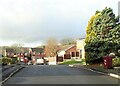
1
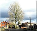
At the junction of Lakenheath Drive and Thornham Drive
A residential development in Sharples.
Image: © philandju
Taken: 9 Dec 2021
0.11 miles
3
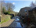
Paper Mill Road, Eagley
Also spelled Papermill Road. The mill has long since disappeared, but the cobbles, or setts, remain.
Image: © philandju
Taken: 2 Feb 2018
0.19 miles
4
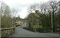
Bridge over Eagley Brook
Where Eagley Way becomes Hough Lane.
Image: © philandju
Taken: 1 Apr 2022
0.20 miles
5
Bridge Mill
The earliest surviving mill on the site, dated to the end of the 18th century.
Image: © Alan Murray-Rust
Taken: 25 Jul 2012
0.21 miles
6
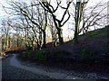
Eagley Bank
The old road to Eagley Mills, now redundant as a road and used only as a footpath.
Image: © philandju
Taken: 26 Jan 2018
0.21 miles
7
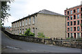
The Old School House, Hough Lane
18th century stone building with mullioned windows, which appears to have been used as the local school before the new school was built in 1852. It currently again serves an educational purpose as it houses a nursery school.
Image: © Alan Murray-Rust
Taken: 25 Jul 2012
0.22 miles
8
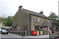
Eagley Mills - Bridge Mill
The oldest building in this complex, this was built around 1780 as a water powered textile mill. It was later used as a canteen for the larger mills on the opposite side of the Eagley Brook. It is Listed Grade II and was converted to cottages in 2003. This idyllic setting was once a major hive of industry.
Image: © Chris Allen
Taken: 30 Mar 2008
0.22 miles
9
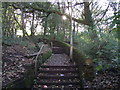
Footpath at Eagley
Connecting Eagley Brow with Eagley Way, the path would have been a direct route from Eagley to Eagley Bank, and would have been used by those workers at Eagley Mills who lived at Eagley Bank.
Image: © philandju
Taken: 19 Oct 2011
0.22 miles
10
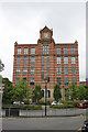
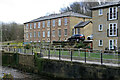
Brook Mill, Eagley - 1
The eastern facade with main entrance and clock tower. The rusticated stone banding is an unusual and distinctive feature.
This view also shows the barrier between Eagley Brow and Hough Lane which prevents unwanted through traffic.
Image: © Alan Murray-Rust
Taken: 25 Jul 2012
0.22 miles