IMAGES TAKEN NEAR TO
Old Kiln Lane, BOLTON, BL1 7PY
Introduction
This page details the photographs taken nearby to Old Kiln Lane, BL1 7PY by members of the Geograph project.
The Geograph project started in 2005 with the aim of publishing, organising and preserving representative images for every square kilometre of Great Britain, Ireland and the Isle of Man.

There are currently over 7.5m images from over14,400 individuals and you can help contribute to the project by visiting https://www.geograph.org.uk
Image Map
Images are licensed for reuse under creativecommons.org/licenses/by-sa/2.0
Notes
- Clicking on the map will re-center to the selected point.
- The higher the marker number, the further away the image location is from the centre of the postcode.
Image Listing (19 Images Found)
Images are licensed for reuse under creativecommons.org/licenses/by-sa/2.0
Image
Details
Distance
2
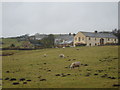
Rants Farm
On Old Kiln Lane (B6402). The barn has been converted into a separate house now.
Image: © Margaret Clough
Taken: 16 Jan 2006
0.08 miles
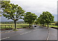
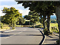
3
Old Kiln Lane
The lane connects Chorley Old Road and Moss Bank Way.
Image: © philandju
Taken: 21 Jul 2020
0.09 miles
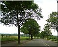
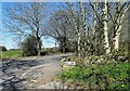
6
Old Kiln Lane
At its junction with Chorley Old Road.
Image: © philandju
Taken: 30 Jul 2024
0.20 miles
7
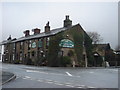
Bob's Smithy Inn
At the corner of Chorley Old Road (B6226) and Walker Fold Road. There was once an actual smithy at the left hand corner, opposite the pub, from which the pub derives its name.
Image: © Margaret Clough
Taken: 16 Jan 2006
0.20 miles
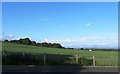
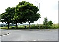
9
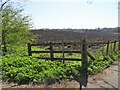
On the corner of Old Kiln Lane and Boot Lane
A ploughed field awaits seeding.
Image: © philandju
Taken: 19 Apr 2021
0.21 miles
10
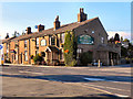
Bob's Smithy Inn
Chorley Old Road, Bolton.
Image: © David Dixon
Taken: 29 Aug 2010
0.22 miles