IMAGES TAKEN NEAR TO
Wincanton Drive, BOLTON, BL1 7PG
Introduction
This page details the photographs taken nearby to Wincanton Drive, BL1 7PG by members of the Geograph project.
The Geograph project started in 2005 with the aim of publishing, organising and preserving representative images for every square kilometre of Great Britain, Ireland and the Isle of Man.

There are currently over 7.5m images from over14,400 individuals and you can help contribute to the project by visiting https://www.geograph.org.uk
Image Map
Images are licensed for reuse under creativecommons.org/licenses/by-sa/2.0
Notes
- Clicking on the map will re-center to the selected point.
- The higher the marker number, the further away the image location is from the centre of the postcode.
Image Listing (25 Images Found)
Images are licensed for reuse under creativecommons.org/licenses/by-sa/2.0
Image
Details
Distance
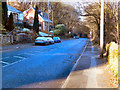
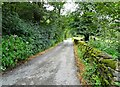
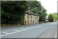
3
Houses on Longworth Lane
In the foreground, Bank House, and further back, Wanstead.
Image: © philandju
Taken: 15 Aug 2023
0.17 miles

6
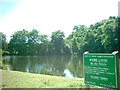
Dunscar
Former Mill Lodge now used as Anglers Association lake.
Just by the side of the A666
Image: © John Lomas
Taken: 7 Aug 2005
0.18 miles
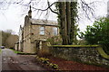
7
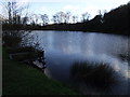
Shore Lodge, Dunscar
Angling lake near Dunscar Bridge.
Image: © philandju
Taken: 5 Jan 2012
0.19 miles
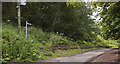
8
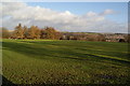
Playing fields at Sharples
Set on higher ground above the valley of Eagley Brook which is in the dip ahead.
Image: © Bill Boaden
Taken: 28 Dec 2011
0.19 miles
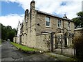
9
Cottages on Blacburn Road
Just south of Dunscar Bridge.
Image: © philandju
Taken: 15 Aug 2023
0.20 miles