IMAGES TAKEN NEAR TO
Ramsay Street, BOLTON, BL1 7HX
Introduction
This page details the photographs taken nearby to Ramsay Street, BL1 7HX by members of the Geograph project.
The Geograph project started in 2005 with the aim of publishing, organising and preserving representative images for every square kilometre of Great Britain, Ireland and the Isle of Man.

There are currently over 7.5m images from over14,400 individuals and you can help contribute to the project by visiting https://www.geograph.org.uk
Image Map
Images are licensed for reuse under creativecommons.org/licenses/by-sa/2.0
Notes
- Clicking on the map will re-center to the selected point.
- The higher the marker number, the further away the image location is from the centre of the postcode.
Image Listing (58 Images Found)
Images are licensed for reuse under creativecommons.org/licenses/by-sa/2.0
Image
Details
Distance
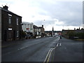
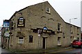
1
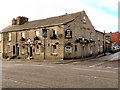
The Brewery Tap
The Brewery Tap, formerly the Carters Arms, at the corner of Ramsey Street and Belmont Road.
Image: © David Dixon
Taken: 20 Nov 2010
0.02 miles
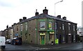
2
The Brewery Tap
The Brewery Tap, formerly the Carters Arms, at the corner of Ramsey Street and Belmont Road.
Image: © David Dixon
Taken: 20 Nov 2010
0.02 miles

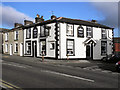
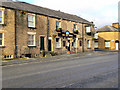
5
The Bay Mare in Astley Bridge
On the corner of Blackburn Road (A666) and Ramsey Street.
Image: © philandju
Taken: 27 Apr 2018
0.03 miles
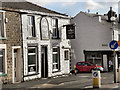
7
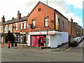
Blackburn Road Post Office, Astley Bridge
Image: © David Dixon
Taken: 20 Nov 2010
0.04 miles
8
The Bay Mare
Blackburn Road, Astley Bridge
Image: © David Dixon
Taken: 20 Nov 2010
0.04 miles
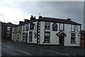
9
The Bay Mare
Public house on the corner of Blackburn Road and Ramsey Street.
Image: © David Dixon
Taken: 20 Nov 2010
0.04 miles