IMAGES TAKEN NEAR TO
Oakbank Drive, BOLTON, BL1 7DG
Introduction
This page details the photographs taken nearby to Oakbank Drive, BL1 7DG by members of the Geograph project.
The Geograph project started in 2005 with the aim of publishing, organising and preserving representative images for every square kilometre of Great Britain, Ireland and the Isle of Man.

There are currently over 7.5m images from over14,400 individuals and you can help contribute to the project by visiting https://www.geograph.org.uk
Image Map (Loading...)


Getting Data...Please wait
Leaflet Map data © OpenStreetMap
Images are licensed for reuse under creativecommons.org/licenses/by-sa/2.0
Notes
- Clicking on the map will re-center to the selected point.
- The higher the marker number, the further away the image location is from the centre of the postcode.
Image Listing (17 Images Found)
Images are licensed for reuse under creativecommons.org/licenses/by-sa/2.0
Image
Details
Distance
2
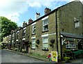
Whitehill Cottages
A nicely kept row of grade II listed stone cottages off Belmont Road in north Bolton.
Image: © philandju
Taken: 23 Jul 2024
0.12 miles
3
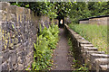
A chicane in the path that makes the continuation from the east almost invisible
Image: © Ian Greig
Taken: 24 Jun 2011
0.12 miles
4
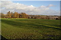
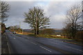
Playing fields at Sharples
Set on higher ground above the valley of Eagley Brook which is in the dip ahead.
Image: © Bill Boaden
Taken: 28 Dec 2011
0.12 miles
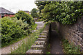
5
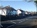
Open country ahead
This is the end of the built-up area, though the houses continue a little further on the left.
Image: © Bill Boaden
Taken: 28 Dec 2011
0.13 miles

8
Gap in the hedge off Belmont Road
The current edge of built up Bolton, but the field looks as if it has seen very little agricultural activity of late.
Image: © Richard Webb
Taken: 22 Nov 2021
0.16 miles
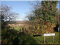
9
An unused field off Belmont Road
On the edge of Bolton and probably soon to become part of Bolton.
Image: © Richard Webb
Taken: 22 Nov 2021
0.16 miles
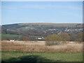
10
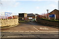
Sweetloves water treatment works
Seen from Belmont Road though the active entrance is off Whitehill Lane.
Image: © Bill Boaden
Taken: 28 Dec 2011
0.17 miles